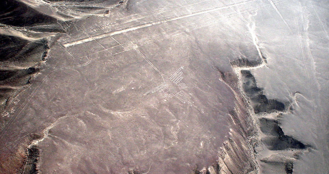
<![CDATA[The Nazca lines in Peru may have marked ancient pilgrimage routes used by two separate groups or peoples, according to research from Yamagata University in Japan. A team led by Masato Sakai analysed 100 of the figures in the Peruvian desert, called geoglyphs, including their location, method of creation and shape, and concluded that they were made in two distinct manners, in different periods of time. What’s more, they lay along roads leading to the ancient religious Cahuachi, dating from the pre-Incan period. Even after the complex stopped being used and drifted into oblivion, the local people continued to make shapes in the desert. It was already known that more than a thousand Nazca lines had been etched into the ground between 200 BCE and 600 CE. Some of them depict animals, others are in the shape of supernatural beings, while others are geometrical shapes. They first gained notoriety in the 1920s, when they were seen from planes flying above the Nazca Plateau. Some of the hypotheses put forward to explain them have been that they create a labyrinth, or that they follow the routes of underground rivers. A third hypothesis, and one supported by the recent analysis, is that they are part of a pilgrimage route. Sakai’s team identified four different styles of Nazca lines, and each of the groups of geoglyphs featuring these styles were located along different routes that ultimately led to Cahuachi. One of the distinctions between the four groups of shapes was their nature itself, and another was the method in which they had been constructed. One of these methods involved removing rocks from the middle of the shapes to create them. The other was the opposite: removing earth along the contours of a shape to reveal the rock underneath. Based on the designs, Masato and colleagues identified two groups of possible makers. One of these apparently drew animals, such as condors, dogs, monkeys, and camelids along a route to Cahuachi that went along the Ingenio river, next to the Ingenio Valley. The other group preferred supernatural creatures, sacrificial scenes and severed heads, which were drawn along another route to the temple complex, passing through the Nazca Valley. Based on this evidence, the research team suggested the two types of geoglyphs were made by two different cultures living in the respective areas. A third group of shapes is considered to have been carved by both groups working together. One further suggestion the Japanese researchers made on the basis of evidence they had unearthed, in this case pieces of smashed ceramic vessels at intersections of the pilgrimage routes, was that the function of the geoglyphs changed with time. In earlier periods the shapes were more likely to have been used as markings of the ritual routes to the temple but later, in the period from which the ceramics pieces have been dated, it is possible that the shapes were used as places for performing rituals involving the destruction of ceramic vessels. After the decline of the Cahuachi complex, the locals continued to make geometrical shapes in the area. Image courtesy of Wikimedia Commons user: Martin St-Amant ]]>
Nazca Lines Marked Pilgrimage Routes