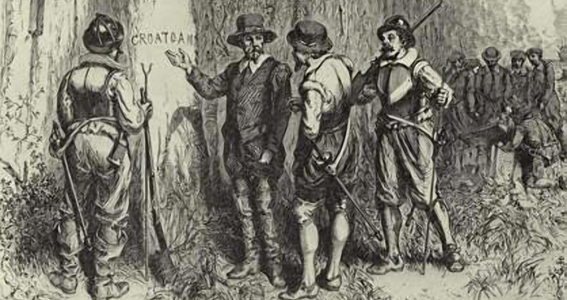
<![CDATA[The Roanoke colony’s disappearance has been the subject of anything from scientific hypotheses to sheer speculation for over four centuries, and now two separate studies have found evidence that supports one of the more widely held hypotheses: the assimilation of the settlers into the local Native American population. It also goes counter to another popular suggestion – that the colonists were slaughtered by these same locals. One of the digs is led by British archaeologist Mark Horton and is located on Hatteras Island, part of what is today known as the Outer Banks off the North Carolina Coast, situated 50 miles southeast of Roanoke Island. The location’s name has been linked to the mysterious word "Croatoan” that was found carved into a fence post on Roanoke Island, the New York Times relates, and to the letters “CRO” carved on a tree in the colony. The reason: Croatoan was the name of the Native American community that lived on Hatteras at the time and the island was itself called Croatoan Island. The dig, organised by East Carolina University, has so far yielded enough artefacts to lead Horton to suggest that there were Europeans living there at some point around 1590, in close contact with Native American populations, the Daily Mail reports. According to the New York Times, the artefacts found on Hatteras Island include a signet ring, the hilt of a rapier, part of a slate writing tablet, part of a horse bridle and part of a gun dating to the late sixteenth century. What wasn’t found at the site, however, were remains of Border ware pottery – the sort of pottery also found on Roanoke Island itself. Speaking about the finds to National Geographic, Horton explained this lack of pottery artefacts is linked to the possibility that after living with the natives for a while, the colonists started discarding the objects they brought with them from Roanoke, save for some heirlooms that they kept. The other dig is perhaps more interesting because it is based on an actual map from the end of the sixteenth century – a map containing a concealed X marking on the mainland of the North American continent. The map was drawn by John White, the leader of the expedition that brought to Roanoke Island its first civilian settlers, including women and children. The first expedition also involved 108 soldiers. The concealed place on the map was noticed by researchers at the British Museum three years ago while they were examining the map using X-ray spectroscopy as well as other modern imaging techniques. It is in the form of a lozenge, which was the usual way of marking a fort, and was drawn with invisible ink, perhaps made from citrus juice, milk or urine, as was the practice for invisible ink in those days. A piece of paper was then glued on top of the map to further conceal the location. The location, now unsurprisingly called Site X, is around 50 miles inland, northwest of Roanoke Island. It is being excavated by a team from the First Colony Foundation led by Nicholas Luccketti. By sheer luck the site has not been disturbed over the years, especially in the immediate past, when there were plans to build a luxury residential complex in that part of Bertie County. The plans fell through because of the global financial crisis, which allowed Luccketti’s team to work with a completely undisturbed site. So far they have uncovered a lot of Border ware pottery as well as other items likely to be used in the everyday life of the colonists, including a food storage jar, pieces of priming pans, a buckle, and a hook on which raw animal hides could be stretched. Luccketti, however, is cautious about making any final conclusions, saying what is fairly certain is that a small number of Europeans occupied the site at some point soon after the disappearance of the Roanoke colony. They were probably then assimilated into the Native American population that inhabited the local area. ]]>
Two Digs Find Evidence of Roanoke Settlers Assimilation