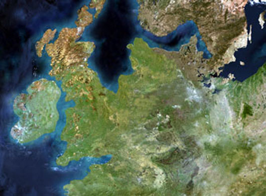
<![CDATA[A new project to map a once-dry landmass in the North Sea that connected mainland Europe and the British Isles is being led by a Lampeter geo-archaeologist. Dr. Martin Bates, from the University of Wales Trinity Saint David, is spearheading the efforts to bring the landmass – lost to flooding around 7,500 years in the past after the melting of massive ice sheets in the region – through a combination of DNA analysis, carbon dating, and digital underwater mapping techniques. The region, which has been come to be known as Doggerland, existed just off the coast of Norfolk; hopes are high that the multi-disciplinary approach will be able to yield computer models of not just the landscape, but of the human inhabitants of the region. In an interview with BBC News, Dr. Bates remarked that the team is examining a time period starting at the inception of Mesolithic around 10,000 years in the past to as far back as another 5,000 years, near the end of the Paleolithic. The climate in the region at that point in time was much colder, the geo-archaeologist added, stating that most humans at that time hunted reindeer. The human inhabitants at the time, which were likely to have an average lifespan of just 40 years, were unlikely to notice much in the way of the landscape changing as these ice sheets melted, Dr. Bates said. However, there would have been occasional events that were much more sudden, like tidal waves and flash floods. The scientist was careful to not characterize the Doggerland region as being “abandoned” by its inhabitants; he referred to the humans of the time and place as highly adaptable, adjusting to new coastlines and learning to exploit marine resources like shellfish. The idea behind a lost landmass roughly equivalent to the size of Ireland isn’t new. In fact, there were theories as to the existence of Doggerland as far back as the latter days of the 19th century. However, the full extent of the lost land didn’t become fully apparent until North Sea oil and gas surveying revealed how right those early estimates turned out to be. Dr Bates and his team have plans to drill down as far as six meters in order to retrieve core samples from the seabed to be analyzed. This will allow DNA to be extracted not just from the remains of any humans that lived in the region but also the remains of any animals and plants that played a pivotal role in the survival of these groups of people; the deeper one drills, said the scientist, the farther back in time you can go – this creates not just a physical or geographical map but shows how conditions in the region changed over the course of time. The entire project is expected to take approximately five years. However, the research team expects initial findings as early as 2016.]]>
Lost North Sea Landmass Mapped