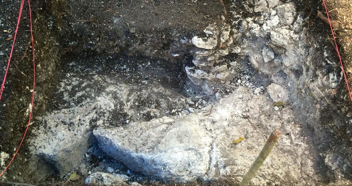
<![CDATA[Researchers from the University of Cincinnati (UC) have used modern aerial surveying technology to pinpoint ancient Maya water storage sites for study. The ancient Maya, a people who inhabited territories in modern-day Guatemala, Belize, and Mexico, would have made it a priority to collect and conserve water, especially as the region was notoriously bereft of rainfall for more than half the year. While much has been made of the water storage systems of major urban Maya sites, researchers Christopher Carr and Jeffrey Brewer wanted to investigate how more rural Maya accomplished these same goals without the urban infrastructure sites that would have been dominated by the elite. The endeavor began with an aerial survey of Yaxnohcah, an ancient Maya site in the Central Yucatan that has been dated to as old as 900 BCE. LiDAR, or Light Detection and Ranging, is a highly advanced light sensing technology that can take as many as 30,000 measurements a second. The apparatus, when mounted to an airplane, is capable of mapping the ground to a remarkably high resolution, providing topographical ground surface data even through densely forested areas, and can provide much-needed respite for archaeologists by making it unnecessary for a field survey in regions of high vegetation such as the Yucatan. The researchers from UC found, based on the LiDAR data and subsequent on-site excavations, several sites within Yaxnohcah that could have been residential water tanks designed to store water gathered during the rainy season in order to last through the seven months of the year that are characterized as dry. The LiDAR sweeps pinpointed in excess of 100 depressions in the ground that might have been reservoirs, only a handful have been investigated so far. Based on archaeological evidence gathered during these excavations, only some seem to have been used as water features. In a UC press release, Brewer explained that investigation sites close to residential structures were chosen; three of the five support the theory that these depressions were household-accessible water sources. Of the three, one was a depression that might have been used as a localized horticultural or agricultural site, a limestone quarry repurposed to hold water, and a seemingly purpose-built reservoir. Brewer added that soil layer evidence revealed that these water storage systems may have been lined with a thick plaster-like clay that would have made it easier for the reservoirs to hold water. The limestone geology of the region would have necessitated the move, as the highly porous rock would have simply drained away over time without some sort of sealant. Additional excavations could lead to further revelations, the UC scientist remarked, especially when it comes to agricultural pursuits. A rural community would have needed water for more than just personal use, as regions that grew cotton or maize would have needed to irrigate the soil for their crops. Elevated reservoirs, for example, could have used gravity to feed fields, while lowered ones could have been used to collect runoff from these fields or from paved surfaces. Brewer and Carr presented their findings at the Society of American Archaeology's 81st annual meeting in Orlando, Florida earlier this month. ]]>
Modern Tech Used to Study Ancient Maya Water Storage