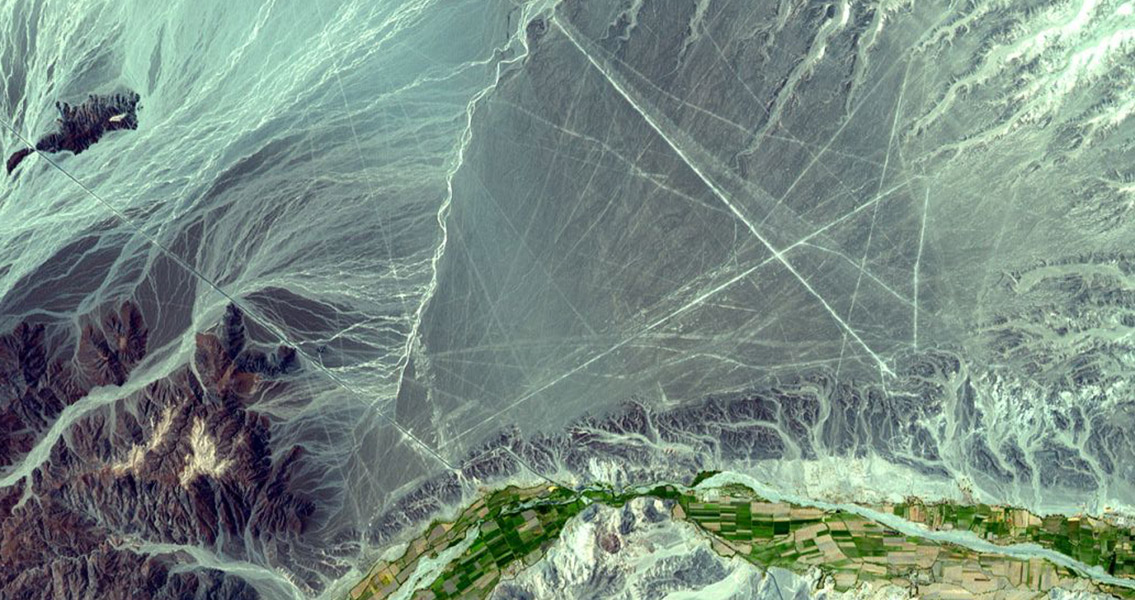
<![CDATA[A new geoglyph at Pampa de Majuelos in the Nazca Desert of southern Peru highlights the archaeological site’s importance to the scientific community once again. The new geoglyph is a 30-meter-long figure representing an animal with a long tongue; on the left side of the figure a head is depicted, while the right side might reveal the legs and body. The figure is believed by researchers to represent an imaginary figure as opposed to an actual animal. Declared a UNESCO World Heritage Site in 1994, the ancient Nazca Lines are a collection of geoglyphs spread across almost 190 square miles of desert, approximately 400 km south of Lima. The Nazca Lines, experts believe, were created between 500 BCE and 500 CE by the Nazca culture. The individual figures, of which there are hundreds, vary in complexity from simple lines and geometric shapes to intricate drawings of animals (hummingbirds, monkeys, spiders, fish, lizards and sharks for example) and other phytomorphic shapes such as flowers and trees. The newly discovered geoglyph was created by removing stones and then piling them up to form a bas-relief, a characteristic geoglyph technique which may date back 2000 to 2500 years ago. In 2011, other geoglyphs were discovered in the same area: two anthropomorphic figures illustrating a decapitation scene. The researchers noted in a National Geographic article that the route to the Cahuachi ceremonial site would have been a path between the geoglyphs, suggesting their link to a religious pilgrimage. Scholars differ as to the purpose of the lines but they are generally considered to have a religious significance, and contrary to popular belief you don’t have to be airborne to see the figures and lines, they’re visible from the top of surrounding foothills. Given the region’s isolation and its dry, windless climate, the lines have remained mostly undisturbed and naturally preserved. The first written mention of the Nazca Lines is in a book written in 1553 by Pedro Cieza de León (he mistakenly thought they were trail markers), but there was little interest in them until Toribio Mejia Xesspe, a Peruvian archaeologist, came across them while hiking in 1927 and later discussed them at a conference. Historians, archaeologists, and mathematicians have all attempted to explain the purpose of the Nazca Lines. Figuring out how they were made has been much easier – to construct the lines, the Nazca people would have only needed simple tools and basic surveying equipment. Wooden stakes have been found at the end of some lines, still in the ground. One of these stakes has been carbon-dated and is the basis for the age that’s been established for the design complex. The lines were typically made by forming a shallow trench, between 10cm and 15cm (4in and 6in) deep. The trenches were created by removing the layer of reddish-brown stones that blanket the desert’s surface, thereby revealing the light-colored earth beneath it and producing lines which sharply contrast with the surrounding surface. This sublayer of ground contains a high amount of lime which hardens and forms a protective layer, shielding the lines from the wind and preventing erosion. Image courtesy of NASA's Earth Observatory ]]>
Discovery of New Geoglyph Keeps the Nazca Lines from Fading