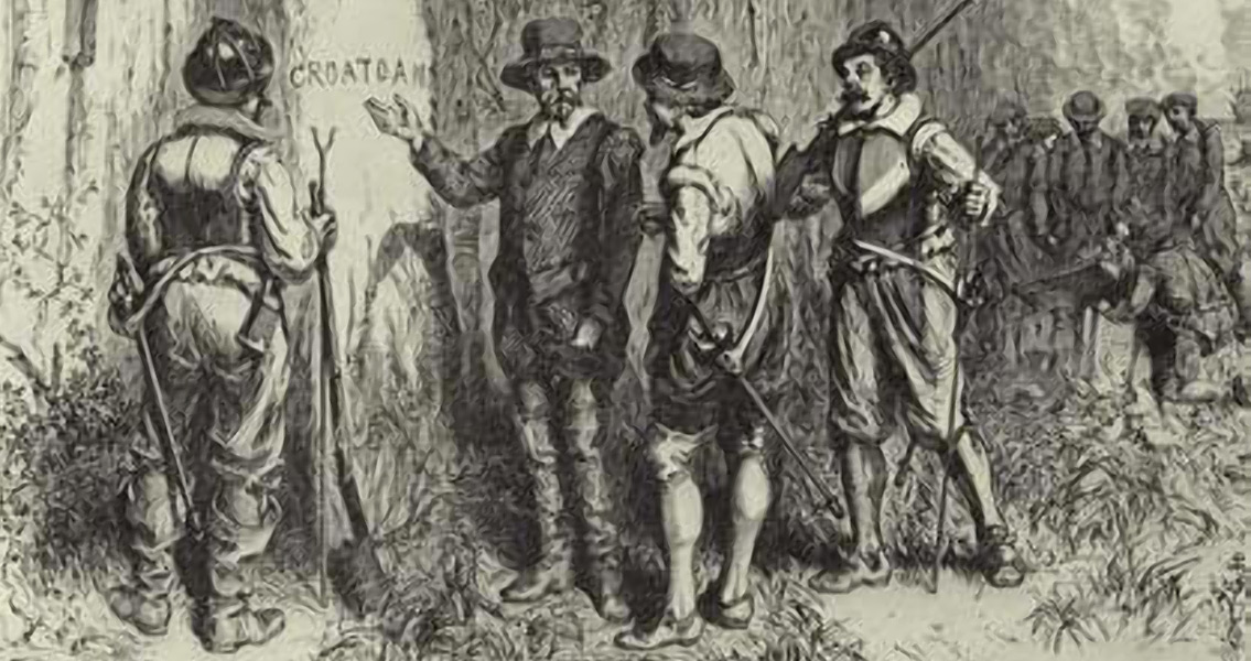
<![CDATA[In 1587, a group of 115 colonists led by John White arrived at Roanoke Island with directions to establish a permanent English colony in the New World. Later that same year, then Governor White returned to England for supplies, leaving behind his daughter and newborn granddaughter – the first English child to be born in the Americas, expecting to return in just a few months. Delayed by the continuing war with Spain, it would be three years before he returned, in August 1590, on his granddaughter’s birthday. All he found was an abandoned settlement, the word “Croatoan” carved into a wood post and a tree with the letters CRO carved on it. There was no trace of the 90 men, 17 women and 11 children he had left behind, who are known today as the Lost Colony, and whose fate remains a mystery hundreds of years later. The Croatoan were a Native American tribe who lived nearby. Roanoke Island is on the Outer Banks off the coast of North Carolina, and in 2007 an archaeological search for historical artifacts was undertaken prior to development. Named site “X”, the team of researchers discovered pieces of early English pottery as well as the remains of a Native American village. The development didn’t happen, but the archaeological work did, and now archaeologists have excavated approximately 850 square feet of the property in question and unearthed dozens of artifacts, including bale seals (metal “tags” found on bales of cloth), parts from guns used at the time, pieces of clothing, and shards of pottery used for storing salted and dried fish. Archaeologist Clay Swindell, with the Museum of the Albemarle, explained in the Virginian-Pilot that the findings may not offer definitive proof that the Lost Colony settled there, but they do show, at a minimum, that they could have; adding that there are numerous time periods represented at the Bertie site (renamed for the county it’s located in). Another critical piece of the puzzle is a map of the area drawn by fellow explorer John Smith, in the 1850’s, which is preserved at the British Museum in London, where researchers found the symbol of a fort underneath a repair patch – the symbol indicates a fort in the same location as the artifacts. Additionally, prior to leaving for England, White had instructed the colonists to “remove 50 miles into the main.” The Bertie site is approximately 57 miles from Roanoke Island. Years later, after the establishment of Jamestown, where White also had a significant role, a search party was sent south to look for the colonists. The party never arrived at the Bertie site, due to ongoing conflicts with the Native Americans in the area. During his time at Roanoke Island, Smith produced a number of maps and watercolor sketches of native Algonkin peoples and the surrounding landscape, considered to be the most informative drawings of the Native American culture in the region. The surviving watercolors are stored at the British Museum. White never fully recovered from the loss of the Roanoke colony, and he would never return to the New World. The excavation efforts haven’t unearthed any evidence of an actual fort, as the map showed, only evidence of a small number of early English settlers. Mysteriously however, Swindell is quoted in the Virginian-Pilot as saying, “We have new clues, that’s all we can say, there are new clues.” ]]>
Could Site “X” Mark the Location of the Lost Colony?