Categories
Breaking News

Faeces Reveals Hippocrates' Parasites: The History News of the Week

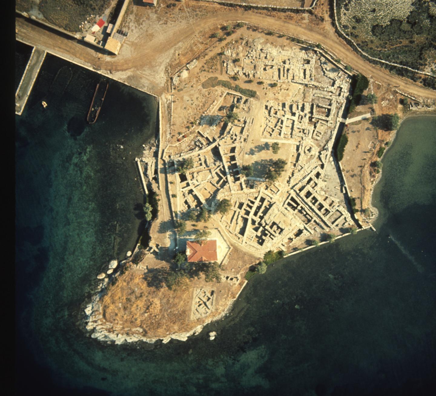
Faeces Reveals Parasites Described by Hippocrates The first archaeological evidence of parasitic worms described in the works of Hippocrates has been discovered on the Greek island of Kea. Archaeologists made the discovery by examining faeces from prehistoric burials on the island. Evilena Anastasiou and Piers Mitchell, two researchers from the University of Cambridge, used microscopy to study soil formed from decomposed faeces recovered from the pelvic bones of skeletons buried in the fourth millennium BCE, second millennium BCE, and the Roman period between 146 BCE and 330CE. Athens based experts in Ancient Greek archaeology and anthropology Anastasia Papathanasiou and Lynn Schepartz worked with the Cambridge team on the project. The team found eggs from two species of parasitic worm (helmiths) were present: whipworm (Trichuris trichiura) and roundworm (Ascaris lumbricoides). Alive in the fifth and fourth centuries BCE, Hippocrates is regarded as a crucial pioneer in medical history. He developed the ground-breaking humoural theory to explain why people became ill. This theory, which stated that a healthy body had a balance of four humours, was the accepted model for explaining disease in Europe up until the seventeenth century. Hippocratic texts referred to intestinal worms known as Helmins strongyle, Ascaris and Helmins plateia. Until now, historians have had to rely on ancient written descriptions of these worms to try and determine exactly which parasites were afflicting the Ancient Greeks. The authors of this latest study, which has been published in the Journal of Archaeological Science: Reports, say that the new evidence identifies beyond doubt some of the parasites that infected people in the region. “The Helmins strongyle worm in the ancient Greek texts is likely to have referred to roundworm, as found at Kea. The Ascaris worm described in the ancient medical texts may well have referred to two parasites, pinworm and whipworm, with the latter being found at Kea,” said study leader Piers Mitchell, from Cambridge’s Department of Archaeology. “Until now we only had estimates from historians as to what kinds of parasites were described in the ancient Greek medical texts. Our research confirms some aspects of what the historians thought, but also adds new information that the historians did not expect, such as that whipworm was present”. Anastasiou explained the significance of the discovery. “Finding the eggs of intestinal parasites as early as the Neolithic period in Greece is a key advance in our field. This provides the earliest evidence for parasitic worms in ancient Greece.” Societies Evolve Along Similar Paths A major new study claims that human societies, from the Incas to modern Britain and China, have evolved along similar paths. The authors argue that despite the myriad differences between societies they tend to become more complex in “highly predictable ways”. To reach their conclusions, the international research team created a database of historical and archaeological information on 414 societies spread across a 10,000-year period. According to the researchers, this database is larger and more systematic than any that has been created before. “Societies evolve along a bumpy path – sometimes breaking apart – but the trend is towards larger, more complex arrangements,” said corresponding author Dr Thomas Currie, of the Human Behaviour and Cultural Evolution Group at the University of Exeter’s Penryn Campus in Cornwall, in a press release. “Researchers have long debated whether social complexity can be meaningfully compared across different parts of the world. Our research suggests that, despite surface differences, there are fundamental similarities in the way societies evolve. “Although societies in places as distant as Mississippi and China evolved independently and followed their own trajectories, the structure of social organisation is broadly shared across all continents and historical eras.” The team’s study has been published in the Proceedings of the National Academy of Sciences. Indonesian Island Contains a Treasure Trove of Cave Paintings A tiny Indonesian island has been found to be unusually rich in cave paintings, according to researchers from the Australian National University (ANU). 28 rock art sites dating from at least 2,500 years ago have been uncovered on the island of Kisar, which measures just 81 square kilometres and lies north of Timor-Leste. According to Sue O’Connor, a professor from ANU’s School of Culture, History and Language, and the lead archaeologist on the recent excavations, these paintings give insight into the region’s history of trade and culture. “Archeologically, no one has ever explored this small island before,” Professor O’Connor said. “These Indonesian islands were the heart of the spice trade going back for thousands of years. The paintings we found depict boats, dogs, horses and people often holding what look like shields. Other scenes show people playing drums perhaps performing ceremonies.” The paintings suggest a stronger shared history between Kisar and nearby Timor than previously thought. “The Kisar paintings include images which are remarkably similar to those in the east end of Timor-Leste,” O’Connor said. “A distinctive feature of the art in both islands is the exceptionally small size of the human and animal figures, most being less than 10 centimetres. Despite their size, however, they are remarkably dynamic.” Professor O’Connor believes that the relationship between the two islands extends back 3,500 years ago to the Neolithic period, which saw an influx of Austronesian settlers who introduced domestic animals and possibly cereal crops. Similarities between some of the painted figures and images cast on metal drums that started to be produced in northern Vietnam and southwest China about 2,500 years ago and traded through the region, suggest some of the paintings were more recent. “These paintings perhaps herald the introduction of a new symbolic system established about two thousand years ago, following on the exchange of prestige goods and the beginning of hierarchical societies,” O’Connor said. Featured image: This is the excavation of the site of Ayia Irini on the island of Kea, where the samples used in the study were found. Credit: Department of Classics, University of Cincinnati ]]>
Categories
Breaking News

Caesar's Landing in Britain – The History News of the Week

Site of Julius Caesar’s Invasion of Britain Discovered Archaeologists have discovery the first evidence of Julius Caesar’s invasion of England. Based on their findings, the archaeologists from the University of Leicester suggest the first landing of Caesar’s fleet in Britain took place in 54BCE at Pegwell Bay on the Isle of Thanet, at the north-east point of the county of Kent. Significantly, the topography of Pegwell Bay, with its visibility from the sea, large open bay and nearby higher ground, is consistent with Caesar’s account of the first landing. The project came about following the discovery of a large defensive ditch in archaeological investigations prior to the building of a new road close to a hamlet in Thanet. This ditch, in Ebbsfleet, is similar to Roman defences at Alésia in France where the decisive battle in the Gallic War took place in 52 BCE. 4-5 metres wide and 2 metres deep, the ditch has been dated by pottery found on site and radio carbon dating to the first century BCE. The archaeological team believe the site covers up to 20 hectares, and the fort was constructed to protect the ships of Caesar’s fleet that had been drawn up on a nearby beach. Dr Andrew Fitzpatrick, research associate from the University of Leicester’s School of Archaeology and Ancient History, said: “The site at Ebbsfleet lies on a peninsular that projects from the south-eastern tip of the Isle of Thanet. Thanet has never been considered as a possible landing site before because it was separated from the mainland until the Middle Ages. “However, it is not known how big the Channel that separated it from the mainland (the Wantsum Channel) was. The Wantsum Channel was clearly not a significant barrier to people of Thanet during the Iron Age and it certainly would not have been a major challenge to the engineering capabilities of the Roman army.” Fitzpatrick detailed the similarities between Caesar’s account and the Thanet site. “Sailing from somewhere between Boulogne and Calais, Caesar says that at sunrise they saw Britain far away on the left-hand side. As they set sail opposite the cliffs of Dover, Caesar can only be describing the white chalk cliffs around Ramsgate which were being illuminated by the rising sun,” he explained in a press release. “Caesar describes how the ships were left at anchor at an even and open shore and how they were damaged by a great storm. This description is consistent with Pegwell Bay, which today is the largest bay on the east Kent coast and is open and flat. The bay is big enough for the whole Roman army to have landed in the single day that Caesar describes. The 800 ships, even if they landed in waves, would still have needed a landing front 1-2 km wide. “Caesar also describes how the Britons had assembled to oppose the landing but, taken aback by the size of the fleet, they concealed themselves on the higher ground. This is consistent with the higher ground of the Isle of Thanet around Ramsgate. “These three clues about the topography of the landing site; the presence of cliffs, the existence of a large open bay, and the presence of higher ground nearby, are consistent with the 54 BCE landing having been in Pegwell Bay.” Sea Level Rises Threatening 13,000 US Archaeological Sites Rising sea levels could impact thousands of archaeological sites on the southeastern US Gulf and Atlantic coasts, new researched published in the journal PLOS ONE claims. David Anderson from the University of Tennessee, Knoxville, USA, and colleagues predict that if projected trends in sea level rises continue, up to 13,000 recorded archaeological sites will be submerged by a 1 metre rise in sea level by the end of the century. This figure does not take into account sites that have not yet been unearthed, suggesting the damage could be even greater. To estimate the impact of sea-level rises, Anderson and his team studied data from the Digital Index of North American Archaeology (DINAA). DINAA aggregates archaeological and historical data sets from the past century from numerous sources, providing a comprehensive insight into the history of human settlement. According to a University of Tennessee statement, large linked data sets like DINAA are vital for showing what is at threat from sea level rises, and can help in planning a response, whether it be mitigation, or taking samples from sites that are at risk. “Sea-level rise in the coming years will destroy vast numbers of archaeological sites, buildings, cemeteries, and cultural landscapes. Developing informatics capabilities at regional and continental scales like DINAA (Digital Index of North American Archaeology) is essential if we are to effectively plan for, and help mitigate, this loss of human history,” Anderson noted. Secrets of 1-900-Year-Old Mummy Revealed With X-Rays Scientists are using pioneering techniques to unravel the mysteries of a young girl mummified in Egypt 1,900 years ago. The mummy was subjected to an all-day X-ray scattering experiment at the Argonne National Laboratory by scientists and students from Northwestern University. It was the first time the technique had been applied to study a human mummy. “This is a unique experiment, a 3-D puzzle,” said Stuart R. Stock, research professor of cell and molecular biology at Northwestern University Feinberg School of Medicine, who led the synchrotron experiment. “We have some preliminary findings about the various materials, but it will take days before we tighten down the precise answers to our questions. We have confirmed that the shards in the brain cavity are likely solidified pitch, not a crystalline material.” The Roman-Egyptian mummy is one of only approximately 100 portrait mummies in the world. Portrait mummies have a lifelike painting of the deceased individual on the mummy wrappings, directly over the deceased’s face. These ‘2D portraits’ were introduced to Egyptian culture by the Romans. Previously, idealised 3D images had been used, such as the iconic burial mask of Tutankhamun. Measuring just 3 feet in length, the girl’s body is swaddled in linen. The outer wrappings have been arranged into an ornate geometric pattern. The image of the face is painted with beeswax and pigment. It gazes outward with a serene look, the body dressed in a crimson tunic and gold jewellery. The students from Northwestern University found that the mummy of the girl, which is stored at Garrett-Evangelical Theological Seminary on Northwestern’s Evanston campus, had notable differences to portrait mummies at Phoebe A. Hearst Museum of Anthropology at the University of California, Berkeley. This suggests it came from a different workshop despite being discovered at the site of Hawara, close to Tebtunis, where the Hearst Museum’s mummy portraits are originally from. “Intact portrait mummies are exceedingly rare, and to have one here on campus was revelatory for the class and exhibition,” said Marc Walton, a research professor of materials science and engineering at Northwestern’s McCormick School of Engineering. As well as providing insights into Egyptian-Roman mummification techniques, the ground-breaking studies being carried out by Northwestern University will help guide preservation of the mummy. The research will culminate in an exhibition at Block Museum titled: “Paint the Eyes Softer: Mummy Portraits from Roman Egypt.” Featured image: The Ebbsfleet Excavation with Pegwell Bay and Ramsgate. Image courtesy of University of Leicester. ]]>