Categories
Breaking News

World’s oldest beer brewery discovered in Israel

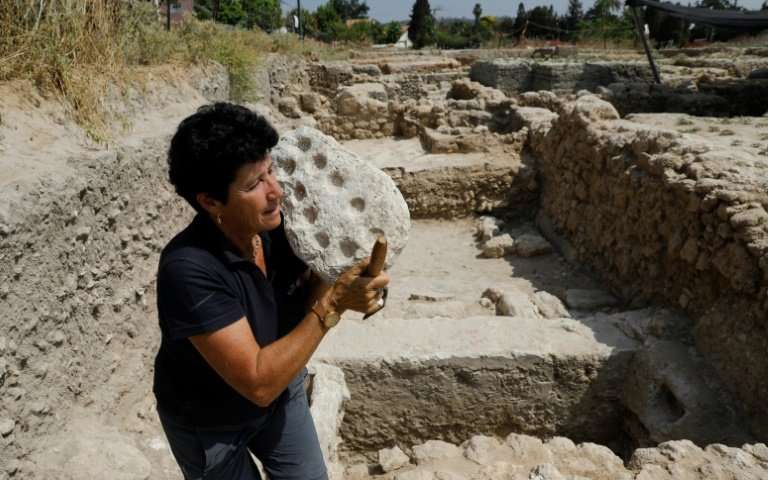
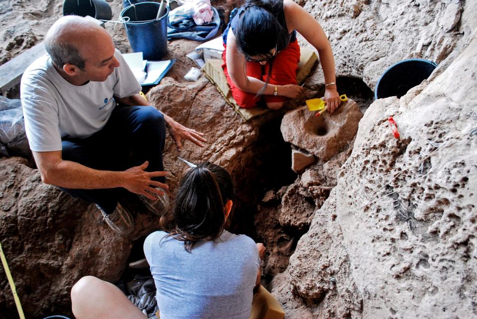
Archaeologists at the beer-making site in a cave near Raqefet, Israel
Photo credit: AFP[/caption]

Who were the Natufians?

The Natufians were semi-sedentary foraging people, living in the Eastern Mediterranean between the Palaeolithic and the Neolithic periods (after the last Ice Age). As part of their rituals, they collected locally available plants, stored malted seeds and made beer.  

A vivid and colourful picture of Natufian ways

Prof. Dani Nadel, Zinman Institute of Archaeology, University of Haifa, Israel, was on the excavation team: “The Natufian remains in Raqefet Cave never stop surprising us. “We exposed a Natufian burial area with about 30 individuals; a wealth of small finds such as flint tools, animal bones and ground stone implements, and about 100 stone mortars and cup marks. “Some of the skeletons are well-preserved and provided direct dates and even human DNA, and we have evidence for flower burials and wakes by the graves. “And now, with the production of beer, the Raqefet Cave remains provide a very vivid and colourful picture of Natufian lifeways, their technological capabilities and inventions.” The results of the study indicate that the Natufians exploited over seven types of plants associated with the mortars. That includes wheat or barley, oat, legumes, and bast fibres like flax. They would then pack plant foods in fibre-made containers and store them in boulder mortars. Bedrock mortars would be used to brew wheat and barley based beer, which would then have likely been served in ritual feasts. [caption id="attachment_8893" align="aligncenter" width="500"] This is the site location and artefacts analysed. (A) The location of Raqefet Cave and three additional Natufian sites in Mt. Carmel; (B) field photos of the studied boulder mortars (BM1,2) and the location of BM3 on the cave floor (scale bar and arrow: 20 cm); (C) a functional reconstruction of the mortars: a boulder mortar used to store plants in a basket with a stone slab on top, and a bedrock mortar used for pounding and cooking plants and brewing beer. Photo credit: Dror Maayan; Graphic design credit: Anat Regev-Gisis[/caption]
Fleshing out our understanding of Natufian society

In July, experts discovered the remnants of what may have been the oldest bread ever baked in Jordan at a site occupied by the Natufian people 14,400 years ago. The fact that beer was brewed at Raqefet Cave 13,000 years ago fleshes out our understanding of Natufian social and ritual realms. It is thought that the brewing of beer inspired people to cultivate cereals in southern Levant – supporting a hypothesis proposed by archaeologists more than 60 years ago.]]>

Categories
Breaking News

Easter Island's society: far more collaborative than we thought

Credit: Wikimedia Commons[/caption]

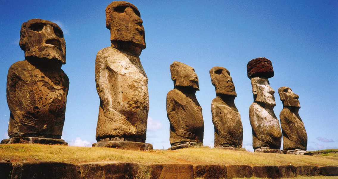
The Easter Island heads: secrets spilled

Field Museum scientist Laure Dussubieux was one of the study’s authors. “For a long time, people wondered about the culture behind these very important statues,” she says. “This study shows how people were interacting, it’s helping to revise the theory.” Lead author Dale Simpson Jr., an archaeologist from the University of Queensland adds: “The idea of competition and collapse on Easter Island might be overstated… To me, the stone carving industry is solid evidence that there was cooperation among families and craft groups.” [caption id="attachment_8696" align="aligncenter" width="800"] Credit: Bjørn Christian Tørrissen via Wikimedia Commons[/caption]

The history of Easter Island

People first arrived on Easter Island around 900 years ago. The society was later scourged by colonists and slavers, but the Rapa Nui culture has persisted. According to oral tradition, the founding population was two canoes led by the island’s first chief. Over the years, the population rose to reach a number of many thousands, making up the complex society that carved the famous Easter Island statues, or moai. Easter_Island_c1880

Sociopolitical organisation

Although the moai are colloquially known as ‘the Easter Island heads,’ they are actually full-body figures that have been part-buried over time. There are nearly a thousand of the statues, with the largest standing at 70 ft tall. “Ancient Rapa Nui had chiefs, priests, and guilds of workers who fished, farmed, and made the moai. There was a certain level of sociopolitical organisation that was needed to carve almost a thousand statues,” says Simpson.

Rapa Nui excavation

Recent excavations of four statues were conducted by Jo Anne Van Tilburg of Cotsen Institute of Archaeology, UCLA and director of the Easter Island Statue Project, along with her Rapa Nui excavation team. Van Tilburg worked with Simpson and Dussubieux to analyse 21 of roughly 1,600 stone tools discovered in the excavations. Around half were fragments that suggested how they were used, giving us a better understanding of the society that erected the statues. Easter Island Maori

The Easter Island production industry

For Van Tilburg, the goal of the project was to gain a better understanding of how tool makers and statue carvers may have interacted, thus gaining insight into how the statue production industry functioned. Dussubieux explains: “We wanted to figure out where the raw materials used to manufacture the artefacts came from… We wanted to know if people were taking material from close to where they lived.” The results pointed to a society that involved consistent collaboration. “The majority of the [tools] came from one quarry complex–once the people found the quarry they liked, they stayed with it,” says Simpson. “For everyone to be using one type of stone, I believe they had to collaborate. That’s why they were so successful–they were working together.” Easter Island

An interactive society from day one

This level of large-scale cooperation flies in the face of the popular narrative that Easter Island’s inhabitants warred themselves into extinction after running out of resources. Van Tilburg urges caution in interpreting the study’s results. “The near exclusive use of one quarry to produce these seventeen tools supports a view of craft specialization based on information exchange, but we can’t know at this stage if the interaction was collaborative. It may also have been coercive in some way. Human behaviour is complex. This study encourages further mapping and stone sourcing, and our excavations continue to shed new light on moai carving.” Simpson says: “There’s so much mystery around Easter Island because it’s so isolated, but on the island, people were, and still are, interacting in huge amounts.”]]>

Categories
Breaking News

Climate change greatly impacted extinction of Neanderthals

What are stalagmites? Stalagmites grow in thin layers each year and any change in temperature alters their chemical composition. The layers therefore preserve a natural archive of climate change over many thousands of years. The researchers examined stalagmites in two Romanian caves, which revealed more detailed records of climate change in continental Europe than had previously been available. From looking closely at the layers of the stalagmites, the archaeologists were able to identify a series of prolonged cold and dry periods in Europe between 44,000 and 40,000 years ago. Temperatures would gradually cool, staying very cold for centuries or even millennia, and then warm up again very abruptly.

Neanderthal presence declined during cold periods

These cold periods coincide with the timings of a near complete absence of archaeological artefacts from the Neanderthals. From this, it has been suggested that changes in climate had a significant impact on the long-term survival of Neanderthal man. [caption id="attachment_8774" align="aligncenter" width="500"] A model an adult Neanderthal male head and shoulders on display in the Hall of Human Origins in the Smithsonian Museum of Natural History in Washington, D.C. Credit: Tim Evanson[/caption] Dr Vasile Ersek is co-author of the study and a senior lecturer in physical geography in Northumbria University’s Department of Geography and Environmental Sciences. He explains: “The Neanderthals were the human species closest to ours and lived in Eurasia for some 350,000 years. However, around 40,000 years ago – during the last Ice Age and shortly after the arrival of anatomically modern humans in Europe – they became extinct. “For many years we have wondered what could have caused their demise. Were they pushed ‘over the edge’ by the arrival of modern humans, or were other factors involved? Our study suggests that climate change may have had an important role in the Neanderthal extinction.”

Why did modern humans survive cold periods?

The researchers have stated that modern humans survived these cold conditions – known as stadial periods – because they were more adaptable to their environment. [caption id="attachment_8773" align="aligncenter" width="500"] Credit: Le Moustier Neanderthals by Charles R Knight, 1920[/caption] While Neanderthals were skilled hunters and were able to use fire, their diet wasn’t as diverse as that of modern humans. They lived mainly on meat, so when that food source became more scarce during colder periods, Neanderthals became vulnerable. By this time, modern humans had begun to incorporate fish and plants into their diet – potentially marking them for survival.

Depopulation, repopulation

According to Dr Ersek, the research team’s findings have indicated that this cycle of “hostile climate intervals” over thousands of years, in which the climate varied abruptly and was characterised by extreme cold temperatures, was responsible for the future European demographic. “Before now, we did not have climate records from the region where Neanderthals lived which had the necessary age accuracy and resolution to establish a link between when Neanderthals died out and the timing of these extreme cold periods,” he said, “But our findings indicate that the Neanderthal populations successively decreased during the repeated cold stadials. “When temperatures warmed again, their smaller populations could not expand as their habitat was also being occupied by modern humans and this facilitated a staggered expansion of modern humans into Europe. “The comparable timing of stadials and population changes seen in the archaeologic and genetic record suggests that millennial-scale hostile climate intervals may have been the pacesetter of multiple depopulation-repopulation cycles. These cycles ultimately drew the demographic map of Europe’s Middle-Upper Paleolithic transition.” Read more about the difference between Neanderthals and modern humans here.]]>

Categories
Breaking News

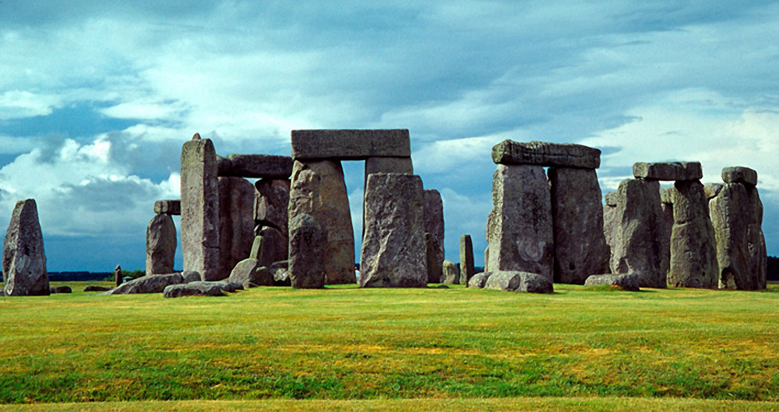
What do we know about the people who built Stonehenge?

Stonehenge (3)

Who built Stonehenge?

The questions of how and why Stonehenge was built garner significantly more research than specifically who built it. That is partly down to the fact that many of the human remains were cremated, making it difficult to extract much useful information from them.

New technique unlocks ancient secrets

Lead author Christophe Snoeck, who is undertaking doctoral research at Oxford’s School of Archaeology, demonstrates that even cremated bone retains its strontium isotope composition, making it possible to investigate where these people had lived during the last ten years of their lives. He says: ‘The recent discovery that some biological information survives the high temperatures reached during cremation (up to 1000 degrees Celsius) offered us the exciting possibility to finally study the origin of those buried at Stonehenge.’ Professor Julia Lee-Thorp, Head of Oxford’s School of Archaeology and an author on the paper, says: ‘This new development has come about as the serendipitous result of Dr Snoeck’s interest in the effects of intense heat on bones, and our realization that that heating effectively “sealed in” some isotopic signatures.’

Stonehenge bodies travelled from Wales

The team analysed the skulls of 25 people who were cremated at the site around 3000 BC to better understand their lives. At least ten of them did not live near Stonehenge at the time of their death. They were far more likely to have been living in western Britain; a region that includes west Wales, the known source of Stonehenge’s bluestones. The research was conducted in partnership with colleagues from University College London, Université Libre de Bruxelles & Vrije Universiteit Brussel), and the Muséum National d’Histoire Naturelle de Paris, France. Rick Schulting, a lead author on the research and Associate Professor in Scientific and Prehistoric Archaeology at Oxford, explains: ‘Some of the people’s remains showed strontium isotope signals consistent with west Wales, the source of the bluestones that are now being seen as marking the earliest monumental phase of the site.’

Inter-regional connections in 3000 BC

The results emphasise the prevalence of inter-regional connections involving the movement of both materials and people in the construction and use of Stonehenge, providing rare insight into the large scale of contacts and exchanges in the Neolithic, as early as 5000 years ago.

A revolutionary analysis technique

Dr Schulting adds: ‘To me the really remarkable thing about our study is the ability of new developments in archaeological science to extract so much new information from such small and unpromising fragments of burnt bone.’ The technique is now regarded as a vehicle to improve our understanding of the past using previously excavated ancient collections. Schulting continues: ‘Our results highlight the importance of revisiting old collections. The cremated remains from Stonehenge were first excavated by Colonel William Hawley in the 1920s, and while they were not put into a museum, Col Hawley did have the foresight to rebury them in a known location on the site, so that it was possible for Mike Parker Pearson (UCL Institute of Archaeology) and his team to re-excavate them, allowing various analytical methods to be applied.’]]>

Categories
Breaking News

Ancient pottery factory discovered in Israel

Family wine businesses During the periods the factory was in use, wine was a major Israeli export. The main function of the jars was of course for the storage and shipment of wine, which was a flourishing industry employing a great number of local people. The remains of around 100,000 jars found buried at the site are thought to have been rejects discarded from the production line. The Israeli Antiquities Authority said in a statement: “The continuous production of these jars probably indicates that the business was a family one, which passed from generation, to generation, to generation.” [caption id="attachment_8870" align="aligncenter" width="500"] The excavation, funded by the Israel Land Authority, was carried out by the Israel Antiquities Authority with the participation of many youth, prior to the construction of a new neighbourhood in Gedera, next to the ancient Tel Qatra. The industrial site comprised a pottery workshop that manufactured storage jars from the third century CE for six centuries. Credit: MENAHEM KAHANA / AFP[/caption]

Gaza jars

The excavation site is not far from the town of Gedera, south of Tel Aviv. Gaza City lies about 30 miles (48 kilometres) southwest of Gedera, on the Mediterranean coast. During its long history, Gaza has been ruled by the Romans, Byzantines, Crusaders, Mamluks and Ottomans. Director of the excavation Alla Nagorsky told journalists at the site that from the 3rd Century AD, the planet produced vessels of a type known to historians as Gaza jars continuously for 600 years.

A luxury production site

Much more than just wine jars, the archaeologists have discovered a factory, an adjacent leisure complex, 20 bathing pools and a room that was used for board games. Alongside the factory were two Byzantine style bathhouses. At least one of them had a heating boiler. The 20 ‘finely constructed’ pools were connected by channels and pipes. “This kind of a place is not built in an instant,” Alla Nagorsky said. “An engineer worked on it. The site is very designed.” “The archaeologists consider that the water complex served both the local population and the many travellers along the ancient main road connecting the port of Gaza with the centre of the country,” the IAA said in its statement.

Backgammon and mancala games

The games room, in particular, was a shock find, with the IAA calling it a ‘rare and surprising discovery’. In it were boards used for playing backgammon and “mancala”, games which are still popular in the area. The statement said the Gedera pottery works may have built the leisure centre for its employees, just as today’s tech and start up companies provide recreation facilities for their workers. [caption id="attachment_8871" align="aligncenter" width="500"] Israel Antiquities Authority archeologist Alla Nagorsky shows a 1600 year-old Mancala game from the Byzantine time found during a large excavation in the central Israeli town of Gedera near the ancient archeological site of Tel Qatra on July 31 2018. Credit: MENAHEM KAHANA / AFP.[/caption]]]>

Categories
Breaking News Editorial

What is Taira rock art, and what does it tell us about ancient desert culture in Chile?

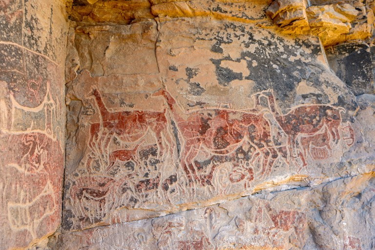
What does the Taira rock art depict? Roughly 90% of the artworks focus on llamas. Some are pregnant, others are suckling their young; and all represent life. The other 10% of the engravings depict the diversity of the desert, with foxes, snakes, ostriches, partridges and dogs featuring in scenes. Human figures are few and far between, and always drawn small. Archaeologists have posited that it is as if painting them small represents just how important desert animals were to their culture and economy. [caption id="attachment_8867" align="aligncenter" width="500"]
View of drawings at the Taira Cave in Chile, located at a height of 3,150 meters, on July 21, 2018. The paintings left by shepherds almost three millennia ago on the walls of the rocks that flank the course of the Loa River. Credit: AFP Martin Bernetti.[/caption]

The role of llamas in ancient desert culture

Archaeologist and curator at Santiago’s Museum of Pre-Colombian Art, Jose Bereguer, says that Taira art is ‘a celebration of life’. First rediscovered by Swedish archaeologist Stif Ryden in 1944, the gallery has been dated to c.400-800 BCE. 16 paintings remain, sitting 3,000 metres above sea level on the banks of the Loa River that traverses the desert. [caption id="attachment_8866" align="aligncenter" width="670"] Archaeologist Jose Bereguer, above, curator at Santiago’s Museum of Pre-Columbian Art, describes the site as “the most complex in South America” because of its astronomical importance as well as the significance to local shepherds. Credit: AFP Martin Bernetti[/caption] Previous studies tell us that the rock art was created by shepherds, who were pleading with the ‘deities that governed the skies and the earth’ to allow their llama flocks to flourish. The Alero Taira drawings, which were created in a natural shelter 30 metres away from the Loa River, give us deeper insight into the role of llamas in ancient desert culture. More than just the lead source of wealth for people inhabiting the desert, the llama was a symbolic creature used in ritual ceremonies throughout the Andes for thousands of years. The ‘Wilancha’, for instance, sees llamas given as sacrifice to ‘Pacha Mama’ (Mother Earth). Volcanoes, like springs, were considered deities by the Atacama natives, while llamas were thought to have been born of springs. Berenguer says: “No one can understand the things done 18,000 years ago because the cultures that did them have disappeared. Here, it’s possible to delve into the meaning because we have ethnography and because there are still people living in practically the same way as in the past.”

Lasting significance for indigenous peoples

The Rumualda Galleguillos is one of roughly 15 indigenous peoples that still raises llamas in the Atacama Desert. Just like their forefathers, it’s a matter of tradition and a way of life. To the Rumualda Galleguillos, these pictures are a ‘testament’ to their ancestors who did not read or write.

UNESCO plans

Now, conservationists want UNESCO to officially recognise the Taira Valley rock art as a heritage site, which will allow them to develop sustainable tourism for the region – similar to Spain’s Cave of Altamira of France’s Lascaux caves.]]>

Categories
Breaking News

14,400-year-old flatbread proves baking predates agriculture by 4,000 years

14,000 year old food practices The excavation at Shubayqa 1 has unearthed 254 examples of food remains. Charred evidence of a flatbread baked 14,400 years ago has caused researchers to confirm that baking predates the advent of agriculture by at least 4,000 years. The findings indicate that bread production encouraged gatherer-hunters to cultivate cereals – therefore contributing to the agricultural revolution in the Neolithic period. The research team was comprised of academics from the University of Copenhagen, University College London and the University of Cambridge. [caption id="attachment_8845" align="aligncenter" width="500"] Dr. Amaia Arranz-Otaegui and Ali Shakaiteer sampling cereals in the Shubayqa area. Credit: Joe Roe[/caption]

From calories to culture: the evolution of eating

Nutritionally speaking, the process of making bread is entirely uneconomic. After harvesting wild cereals, the people of Shubayqa 1 had to separate the seeds, grind them down, make the dough, flatten the dough and cook it. They would have suffered a net loss of calories during the process – which suggests that the bread was not made for survival purposes. That leads us to the idea that this discovery represents a pivot in the history of human eating practices. No longer were people seeking pure nutrition from their food. For the people of Shubayqa 1, eating was now imbued with cultural, social and perhaps ideological significance. To strengthen this theory, the date and location of the flatbread places it close to the erection of the world’s oldest monumental buildings. Inside, ceremonies and rituals took place; perhaps with the first instances of socio-ideological feasting. [caption id="attachment_8846" align="aligncenter" width="500"] One of the stone structures of the Shubayqa 1 site. The fireplace, where the bread was found, is in the middle. Credit: Alexis Pantos[/caption]

Sedentary lifestyles lead to diet changes

The Danish Council for Independent Research has recently approved further funding for research into food production during the transition to the Neolithic period. University of Copenhagen archaeologist Tobias Richter, who led the excavations at Shubayqa 1 in Jordan, comments: “Natufian hunter-gatherers are of particular interest to us because they lived through a transitional period when people became more sedentary and their diet began to change.”

What came first: the chicken or the bread?

Professor Dorian Fuller from the UCL Institute of Archaeology says: “That it was produced before farming methods suggests it was seen as special, and the desire to make more of this special food probably contributed to the decision to begin to cultivate cereals.” Richter continues: “The flat bread found at Shubayqa 1 is the earliest evidence of bread making recovered so far, and it shows that baking was invented before we had plant cultivation. “So this evidence confirms some of our ideas. Indeed, it may be that the early and extremely time-consuming production of bread based on wild cereals may have been one of the key driving forces behind the later agricultural revolution where wild cereals were cultivated to provide more convenient sources of food.” The discovery comes shortly after new research revealed that barley spread across the world via multiple routes – suggesting human choices were made based on nutritional and perhaps cultural needs. Read more here.]]>

Categories
Breaking News

How barley spread across the world & helped culture formation

Different routes – an indicator of different cultures? Due to the fact that there were a number of different eastward routes for the spread of the barley population, the study suggests humans were choosing routes based on particular attributes of acting according to environmental adaptation. Choice and environment, therefore, are crucial factors for the spread of staple foods in prehistory. These different routes include ones to the north and south of the Iranian Plateau; through the Inner Asian Mountain Corridor in Central Asia, possibly connecting up to the Chinese section of the Silk Road; a high altitude spread on the southern edge of the Tibetan Plateau; a high latitude spread through the northern steppe; two distinct spreads into Japan; and a maritime route from South Asia. As previous research has provided radiocarbon dates, we know when the routes were followed. [caption id="attachment_8836" align="aligncenter" width="728"] Map showing proposed routes of spread of six different ancestral populations of barley landraces. Direct radiocarbon dates from archaeological barley grain have enabled the timing of these different routes to be elucidated. Credit: D. Lister[/caption]

Impacting rice-growing in East Asia

Lead author Dr Diane Lister, a researcher at the McDonald Institute for Archological Research at the University of Cambridge, says: “One barley population is widespread, particularly around the coastlines. This population may have travelled eastwards via a maritime route from South Asia, via Southeast Asia. This particular population is made up of winter-sown varieties of barley, which are thought to be important in rice-growing areas of East Asia, where a crop of rice is commonly grown in the summer months, and barley adapted to winter-sowing regimes can be planted after the rice harvest. The development of multi-cropping practices during prehistory is thought to have greatly increased productivity and stability, enabling more complex societies to develop.” [caption id="attachment_8837" align="aligncenter" width="257"] Diane Lister at work in the Glyn Daniel laboratory for archaeogenetics at the McDonald Institute for Archaeological Research, University of Cambridge Credit: A. Clarke[/caption]

Moulding Tibetan culture

“Another barley population predominates on the high Tibetan Plateau. This barley has a naked grain, making it a particularly attractive staple, as it doesn’t require the pearling process that hulled barley requires for human consumption. Along with the herding of yak, this naked type of barley is an essential for the Tibetan way of life, and their importance are clearly seen in the offerings of naked barley grains and yak butter in Tibetan Buddhist temples around the region. The staple carbohydrate eaten by the Tibetans is tsampa, made from roasted naked barley flour and mixed with salty Tibetan butter tea.” [caption id="attachment_8835" align="aligncenter" width="590"] Ethnically Tibetan women winnowing naked barley on a road on the edge of the Tibetan Plateau, near Xiahe, Gansu Province, China.
Photo credits Diane Lister[/caption]

New findings contribute to conversation around climate change

So what does this mean for today? Lister concludes: “Barley is an extremely hardy crop, able to grow in regions where other crops are unable to grow, and is an important staple in such environments. Understanding the spread of its cultivation during prehistory, and the various factors that affected its establishment in different regions of Eurasia, will contribute towards our understanding of climate change and its current and future effects on agriculture.” The paper has been published as a part of the Food Globalization in Prehistory project, funded by the European Research Council and awarded to Prof. Martin Jones. Additional funding was provided by a Royal Society International Joint Project grant.]]>

Categories
Breaking News

Humans left Africa 270,000 years earlier than we thought

One of the tools from the discovery site in Shangchen, China. Credit: Professor Zhaoyu Zhu[/caption] Prior to this discovery, the earliest evidence of humanity outside Africa was a collection of skeletal remains and stone tools found in Dmanisi, Georgia, which have been dated to 1.85 million years ago – 270,000 years after the new discovery in Shangchen in the southern Chinese Loess Plateau. The research, published in the journal Nature, also suggests that the ancient humans returned to the same site repeatedly, possibly for hunting. The collection includes a notch, scrapers, cobble, hammer stones and pointed pieces. Each item shows sign of human use. The hammer stones, for instance, had been intentionally flaked. Fragments of animal bones that would have been contemporaneous with the items were also found. Most of the artefacts were made of quartzite and quartz, suggesting that the materials were sourced from the foothills and streams of the Qinling Mountains around 5 to 10 kilometres from the site. [caption id="attachment_8815" align="aligncenter" width="425"] The extensive collection of 2.1 million years old artefacts is causing archaeologists to reconsider the overall story of human migration. Credit: Professor Zhaoyu Zhu[/caption] Because the 96 stone artefacts were found in 17 different layers of fossil soils that had developed over a period of one million years, we now know that early humans occupied the Chinese Loess Plateau under varying climatic conditions between 1.2 and 2.12 million years ago. Professor Dennell says: “Our discovery means it is necessary now to reconsider the timing of when early humans left Africa.” The find “may add a new chapter to the story of hominin evolution, suggesting that some of these species left Africa far earlier than once believed and managed to travel over 8,000 miles east of their evolutionary birthplace,” The New York Times reports. The age of the tools “suggests that the hominins who made them were neither tall nor big-brained. Instead, they may have been small bipedal apes, with brains about the size of a chimpanzee’s.” Michael Petraglia, a paleoanthropologist at the Max Planck Institute for the Science of Human History comment:S “The implications of all this are large. We must re-evaluate our understanding of human prehistory in Eurasia.”]]>

Categories
Breaking News

Did the Romans hunt whales?

A gray area Due to centuries of whaling, the North Atlantic right whale (Eubalaena glacialis) is currently a threatened species, congregating off eastern North America. The Atlantic gray whale (Eschrichtius robustus) has completely disappeared from the North Atlantic and can only be found in the North Pacific. Neither is found in the Mediterranean today. In fact, it has long been assumed that the Mediterranean was outside the historical range for both species. You can read more about the history of whaling here. [caption id="attachment_8733" align="aligncenter" width="536"] Atlantic Northern Right Whale mother and calf. Credit: Wikimedia Commons[/caption]

Calving season in the Med

Due to the migratory nature of both species of whale, their presence east of Gibraltar means that they would have entered calving season in the Mediterranean Sea. Co-author of the study Dr Camilla Speller, from the University of York, says: “Our study shows that these two species were once part of the Mediterranean marine ecosystem and probably used the sheltered basin as a calving ground. “The findings contribute to the debate on whether, alongside catching large fish such as tuna, the Romans had a form of whaling industry.”

Roman scandal

The paper speculates that small rowing boats and hand harpoons could have been used to capture the creatures; similar to the medieval Basque whaling methods used in the following centuries. Lead author of the study Dr Ana Rodrigues, from the French National Centre for Scientific Research, adds: “[The] Romans did not have the necessary technology to capture the types of large whales currently found in the Mediterranean, which are high-seas species. But right and gray whales and their calves would have come very close to shore, making them tempting targets for local fishermen.”

The ripple effect: what this means for other research

If coastal whales were in fact present in the Mediterranean, some previously perplexing sources suddenly make a lot more sense. Anne Charpentier, lecturer at the University of Montpellier and co-author in the study, said: “We can finally understand a 1st-Century description by the famous Roman naturalist Pliny the Elder, of killer whales attacking whales and their new-born calves in the Cadiz bay. “It doesn’t match anything that can be seen there today, but it fits perfectly with the ecology if right and gray whales used to be present.” As a result, the authors of the study are urging historians and archaeologists to re-examine their material in light of the knowledge that coastal whales were once part of the Mediterranean marine ecosystem. [caption id="attachment_8812" align="aligncenter" width="500"] A Roman mosaic with fishing scene, found in Hippolytus House in greater Madrid, Spain. Credit: Alberto Paredes/Alamy Stock Photo[/caption]

The forgotten calving grounds

“It seems incredible that we could have lost and then forgotten two large whale species in a region as well-studied as the Mediterranean. It makes you wonder what else we have forgotten,” concludes Dr Rodriguez.]]>