Categories
Breaking News

Huge Discovery in the Shadows of Petra

Dawn. Archaeologists throughout the years have been aware that something was there, but most assumed the structure was part of the city’s terrace walls. Tuttle collaborated with Sarah Parcak on the research. Parcak, who is with the University of Alabama at Birmingham, uses satellites to survey a variety of sites. The research team took subsequent excursions to examine and measure the site on the ground. It was during this trip that they unearthed the scattered pottery, which indicates the site could date back to the time Petra was founded. Petra was constructed by the Nabateans in around 150 BCE, when the civilization was accumulating great wealth through trading with the Greeks and Persians. Eventually, the city was absorbed by the Ottoman, Byzantine and Roman empires but its ruins remain famous for the work completed by the city founders, including spectacularly carved facades in the canyons and on the cliffs. It was abandoned sometime around the seventh century, and rediscovered in 1812 by Johann Burckhardt, a Swiss explorer. In addition to the Nabatean pottery, the researchers found fragments of pottery which had been imported from the Hellenistic groups who often traded with Petra, as well as pottery from the Byzantine and Roman eras. In the mountains, canyons and valleys that surround Petra, there are numerous small cultic shrines and various platforms, but nothing matching the scale of the recently discovered platform. It’s believed these sites, along with a big, open plateau called the Monastery, were used for political activities or cultural displays and this newly found platform may have served the same purpose. The giant staircase doesn’t face the city center, meaning it doesn’t have any apparent relationship to Petra, unlike the others, which the researchers see as peculiar. Because the builders didn’t leave any written records it’s difficult to fully understand the purpose of the platforms. Similar to other Semitic cultures at the time, the Nabateans often used an iconic style which indirectly represented their divinities, such as stelae, niches and carved blocks. Sometimes even an empty niche can represent a god. Due to the ongoing trade with other Mediterranean cultures however, the Nabateans also adopted figures as representations as well, with gods that aligned with Zeus and Aphrodite. The work has been published in the Bulletin of the American Schools of Oriental Research, and although there are no current excavations plans at the site, they’re hopeful they will be able to continue their work in the future. ]]>

Categories
Breaking News

Shipwrecks Seen by Landsat Satellites

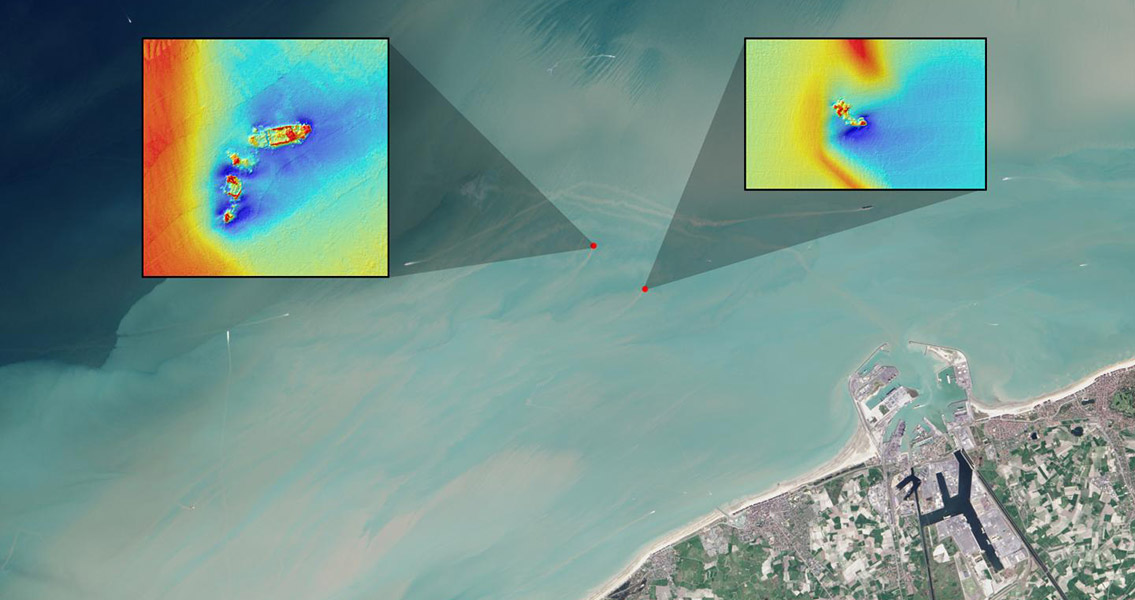
Journal of Archaeological Science. The team of researchers found that shipwrecks close to the coast can leave sediment plumes which are visible on the surface of the sea, revealing their location. Using free data from the Landsat 8 satellite, the team have detected plumes extending as far as 4 km downstream from the site of a shipwreck. It is the first study of its kind to show that Landsat 8 and similar satellites can be used to find shipwrecks in sediment heavy coastal waters. Around three million ships are scattered throughout the planet’s oceans, with the vast majority close to shore due to the abundance of navigational hazards in coastal areas. 25% of all the world’s shipwrecks are estimated to be in the North Atlantic. In particular, the narrow 100 mile stretch of the North Sea which separates England from the Netherlands and Belgium is saturated with Second World War wrecks, a consequence of mines, submarines and warships being deployed during the conflict to disrupt shipping between the Allies and Dutch and Belgian ports. So substantial is the potential environmental threat from these wrecks, the Council of Europe’s Parliamentary Assembly recommended they be mapped and monitored. This was the region that formed the focus of the researchers’ study. Taking the known locations of four shipwrecks from the Second World War: the SS Sansip, the SS Samvurn, the SS Nippon and the SS Neutron, as a starting point, the team mapped sediment plumes extending from the wrecks’ locations using Landsat 8 images and tidal models. They found that two of the wrecks which were mostly unburied created sediment plumes which could be measured during ebb and flow tides. The team suggest that the exposed parts of these ships create pits which fill with sediments during slack tides (when currents are reasonably still). During ebb and flow tides, the sediments are re-suspended in the water, creating the plumes which point to a shipwreck’s location. By mapping sediment plumes during different stages of the tides, the team postulate that it is possible to trace their origins and find as yet unearthed shipwrecks. As long as the waters in which a ship sank are shallow enough for the plumes to reach the surface, it is possible to detect them with optical satellites such as Landsat, according to the authors of the study. As coastal waters, where most shipwreck’s take place, are normally shallow and rich in sediment, the team’s findings could add a valuable new shipwreck detection method to the tool kit of marine archaeologists. Image courtesy of NASA/USGS Landsat image/Jesse Allen, NASA Earth Observatory]]>