

here ]]>

Phys.org late last year. Helen Rougier, an anthropologist from California State University Northridge, led the team studying the broken bones. Inhabited since the Paleolithic Era, the Goyet caves first came to the attention of archaeologists and anthropologists in the nineteenth century. According to the researchers, the proof that the cuts and fractures were due to cannibalism can be found in the bones of other animals close to the caves’ entrance. Horse and reindeer bones had been broken in the same way as the Neanderthals’. Discoveries in the last few years have shown Neanderthals were much more sophisticated than the primitive cavemen they are commonly portrayed as. Studies have revealed evidence that they practiced burial rituals and made an effort to treat the bodies of their dead with care. At the same time however, there has been mounting evidence that they also practiced cannibalism. Until this latest gruesome finding, cases of cannibalism had only been found at Neanderthal sites in southern Europe, such as the El Sidron and Zafarraya sites in Spain, and the Moula-Guercy and Les Pradelles sites in the south of France. The Goyet caves however, are located in the Ardennes Forest in Belgium. The Neanderthal diet has long been a source of interest for anthropologists. Last year, a study in the American Journal of Physical Anthropology claimed that the differences between Neanderthal and modern human anatomy could be explained by differences in diet. Neanderthals were shorter and stockier than humans, with significantly wider rib cages and larger pelvises. The study claimed that these differences were the result of the Neanderthals having to adapt to a high protein diet, especially during brutally cold ice ages. It is suggested in the American Journal of Physical Anthropology study that during the coldest periods of the last ice age, Neanderthals took between 74% and 85% of their caloric intake from animal fats. With the only prey available having been large game, the authors suggest the Neanderthals experienced evolutionary adaptations in the form of bigger livers and renal systems – such adaptations would have also required morphological changes to house the expanded organs. On the other hand, it would be wrong to assume Neandethals were simply carnivores. Another 2016 study suggested that the Neanderthal diet comprised 80% meat and 20% vegetables, based on the isotope composition in the collagen found in their bones. Further stressing just how important vegetables were in the diet of our extinct cousins, a later study determined that this ratio of meat and vegetables was the same even for Neanderthals inhabiting the comparatively barren Mammoth steppe, where plants would have been much harder to come by. The age of the supposedly cannibalised bones from the Goyet Caves, roughly 40,000 years old, is hugely significant. This was a period when the Neanderthals were heading towards extinction. Homo sapiens had arrived in Eurasia, likely creating increased competition for resources and possibly even coming into direct conflict with Neanderthals. Inhabiting Eurasia for tens of thousands of years, Neanderthals were likely as diverse in their behaviour as modern humans are. Findings like those from the Goyet caves add weight to the idea that in times of desperation, the Neanderthals could have been pushed towards cannibalism. ]]>

Ceramics in America. The publication date is listed as March 17th and can be ordered here]]>


Herald Scotland newspaper: “These stones have been linked to Randolph’s skirmish, though I thought they were more likely to be prehistoric and possibly incorporated into the battle. This year I received funding and I have now obtained a radiocarbon date in association with the foundation of the stone. The date that came up is contemporary with the battle. It raises the very real possibility that the stones were constructed to mark the site of Randolph’s victory on the first day.” It was a highly significant battle in that it prevented the English from reaching Stirling Castle, as well as setting up the Scots for their historic victory over the much larger army of King Edward II on the following day. Like a modern day commemorative plaque, the stones, believed to have come from Castle Rock, would have been placed there as a memorial. Police Scotland, who permitted the investigation, have stated that after this new discovery the stones may be made more visible and accessible to the public. Stirling’s Local Area Commander, Chief Inspector Lynn Ratcliff, told The Herald: “These stones are literally in our front yard. We’ve been aware of them, but we did not know their history or background.” The Battle of Bannockburn, during the First War of Scottish Independence, is considered a milestone in Scottish history. The Scots fortress, Stirling Castle, was occupied at the time by the English, and was under siege by the Scottish forces. The English king put together a formidable army to end the siege and keep the castle. His attempt was a failure and his troops were defeated by the much smaller army led by Robert the Bruce, the King of Scots, in a fierce battle. The Wars of Scottish Independence, fought between Scotland and England, started in 1296 with the English initially successful, having won a series of important victories such as the Battle of Dunbar (1296) as well as the Capture of Berwick (1296). However, when Robert the Bruce took the Scottish throne in 1306, the war was restarted. The Bannockburn battlefield is part of the Historic Battlefields in Scotland and is protected by Historic Scotland under the Historic Environment Act. ]]>


The Guardian has revealed a new archaeological initiative to plumb the depths of the Mediterranean to search out the secrets of cities like Atlit-Yam. The program, called Archaeosub, will be spearheaded by Italian researchers. One of these researchers is Benedetto Allotta, head of industrial engineering at the University of Florence, who claims that there are any number of human settlements to be found not far from the Mediterranean coast – with the possibility of several more Atlit-Yams just waiting to be explored. The Archaeosub initiative is focusing on the construction of advanced underwater vehicles (AUVs) that can be operated remotely – partly in an effort to make it more affordable to access the technology. Many academic research organizations have found it difficult to use expensive technologies developed by the offshore oil industry or the military, which has inspired Archaeosub to create lighter, cheaper robotic submersibles that can be easily deployed without having to rely on large research vessels. The project is an ambitious one, and not just for making marine archaeology more accessible. Plans to create underwater Wi-Fi networks through the use of a number of cheap, small Archaeosub AUVs are in the works as well, making it easier for these unmanned robotic vehicles to communicate with one another and the surface. So far Archaeosub has shown promise. A 2016 trial saw Archaeosub test three of its AUVs off the Sicilian coast to survey a well-known shipwreck at Marzamemi. The so-called “church wreck”, a Roman ship that sunk in the sixth century CE hauling marble parts for an early Christian church, was studied by the AUVs, which passed through the site on a lookout for new clues. The vehicles gathered enough data to do a reconstruction of the area, Allotta reported. The researcher and his team hope to perfect wireless communication beneath the surface in order to create an “internet of underwater things” that can send and receive data to boats above or at the shore. This could be challenging, as traditional Wi-Fi works poorly underwater, calling for new technologies relying on GPS data and embracing acoustic wave or even light beam transmission instead. Relay systems that make use of one AUV sending data to another underwater and then that second robot surfacing to create a satellite uplink to send and receive data are also being considered as a possible solution. Allotta says one of the newest sites the team has on its radar is the Gulf of Baratti, off the Tuscan coast, at the site of a 2000-year-old shipwreck that was originally discovered in 1974. The ship is remarkable because of the plethora of medical supplies it was found to have been carrying; Archaeosub hopes to explore the site of the medical supply ship to further refine its methods. ]]>

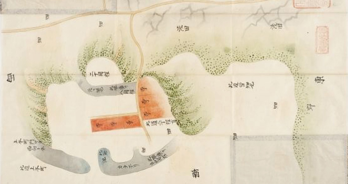
Asahi Shimbun, the Sanada Maru Excavation Promotion Council has announced the discovery in the Tennoji Ward of Osaka’s Esahi-machi district. The private organization recounted how they had found a layer of artificially filled soil at the site, lending weight to their hypothesis that the rectilinear fortress would have been larger than was previously thought. Sanada Maru was a branch of Osaka Castle that would have projected from the south side of the castle’s general frame moat, or Sogamae. The moat would have otherwise defined the furthest border of the castle, built and maintained by the Toyotomi clan. Sanada Nobushige, who also went by the name Sanada Yukimura, was an ally of the Toyotomi during the winter campaign of 1614 at the Siege of Osaka, defending the fortress from the forces of Shogun Tokugawa through 1615 until a peace accord was reached. For many years, the shape of the fortress was thought to have been a semicircle, based on historical drawings. However, Nara University archaeology professor Yohihiro Senda, the leader of the research group, says that he and his colleagues have determined that Sanada Maru could have been square. Senda remarked that the impetus behind this new theory is from not just other drawings but also historical topographic charts as well as aerial photos and additional evidence. The layer of artificial fill was discovered during an excavation across 70 square meters of area near the northern end of the plot, close to what resembled the remains of a moat on an ancient map. A moat-like depression also remains on the southern area, providing indications that there may have been earthworks surrounding the ancient fortress – and researchers feel that the filled-in layer may be evidence of these earthworks. The terrain surrounding Sanada Maru was likely not changed significantly during its demolition, Senda remarked, pointing out that the fill layer was found above natural ground. The professor added that this makes it possible to make estimations as to the size and shape of the fortress by drawing from present-day topographical features. While the site in large part comprises the grounds of the Osaka Meisei Gakuen secondary school, there’s enough leftover evidence to reconstruct Sanada Maru in a rectangular shape, Senda commented. The walls would have run around 300 meters east-to-west and 350 meters from north-to-south, which would have included the breadth of the moat, according to the professor. Senda and his team plan on presenting the entirety of their findings by either February or March of 2017 in a session that will be open to the public. The findings are timely, as the NHK’s annual televised historical drama for 2016 was based on the Siege of Osaka and was in fact called Sanada Maru. Nobushige is of course a central character in the series, portrayed by Japanese television and film actor Masato Sakai. ]]>