Categories
Breaking News

17th century barracks discovered at Elizabeth Castle, Jersey

University of York has discovered new evidence confirming that there was an Army Barracks at Jersey’s Elizabeth Castle during the late 17th Century. The excavation also led the team to uncover a rare brass button, which is thought to have been part of an Army officer’s uniform.

The first major excavation of Elizabeth Castle, Jersey

Built on a rocky islet in St Aubin’s Bay, Elizabeth Castle has defended the shores of Jersey for more than 300 years. Archaeologically speaking, it is a complex site, and has never been excavated in this manner before. It was originally a defensive island fortress during the 16th Century, before falling to occupation by German soldiers during the Second World War. The dig has been conducted alongside Jersey Heritage and originally aimed to discover the location of barracks blocks, allowing historians to learn more about the people that used the building. An archives team from the University of York has worked closely with Jersey Archive to use data for the benefit of the archaeologists. They have since been able to identify four key areas where trenches could be created, which has not only framed the search for artefacts, but also detailed potential evidence of the original structure of the site. The excavation has lasted a week so far, with structural evidence of the barracks, including walls, a cobbled floor and a curious door key, coming to light. [caption id="attachment_8808" align="aligncenter" width="505"] The team also found a key at the site, thought to be contemporary to the site. Credit: University of York[/caption]  

A rare Tudor find: the brass Board of Ordnance button

The brass button comes from the uniform of an officer of the Board of Ordnance, dating to the 18th Century. As there would only have been one Board of Ordnance Officer based at the castle, this is a rare find. Dr Catriona Cooper, from the University of York’s Department of Archaeology, said: “The Board of Ordnance was a government body established in the Tudor period to act primarily as custodians to the areas required in defence of the country. “It is exciting to find this button, because there would have only been one officer that wore this uniform at Elizabeth Castle.  He would have had oversight of the castle’s defences and its army supplies, such as weaponry.” [caption id="attachment_8809" align="aligncenter" width="505"] The brass button is from the uniform of an officer of the Board of Ordnance. Credit: University of York[/caption]
Giant haul of findings from nearby hospital block

Archaeologists are also investigating an early 19th Century hospital block, utilising digital visualisation techniques, to produce a better understanding of the make-up of the building.  It is hoped that the completed work will assist Jersey Heritage to enhance the visitor experience to the site. As part of an ongoing partnership between Jersey Heritage and the University of York, the dig has been much more fruitful than the team had first imagined: “We have also uncovered a comb, tokens and coins, as well as lots of clay pipes ceramics and building materials.  The aim will be to open these finds up to the public and reveal more about the life at the hospital and barracks sites to allow for a clearer window into the past of this fascinating castle site.”]]>

Categories
Breaking News

3-million-year-old skeleton reveals the story of ancient toddlers’ lifestyles

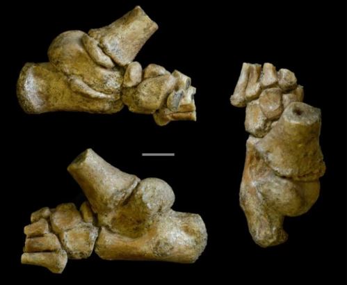
The 3.32 million-year-old foot from an Australopithecus afarensis toddler shown in different angles. Credit: Jeremy DeSilva & Cody Prang[/caption]

A complete 3-million-year-old skeleton

Discovered in 2002 by Zeresenay Alemseged, a professor of organismal biology and anatomy at the University of Chicago, the foot is about the size of a modern human’s thumb. Astonishingly, it is part of an almost complete skeleton of a young female Australopithecus afarensis living 3.32 million years ago in the Dikika region of Ethiopia. “This is the most complete foot of an ancient juvenile ever discovered,” Desilva says. “For the first time, we have an amazing window into what walking was like for a two-and-a-half-year-old, more than 3 million years ago.”

 “On the cusp of being human”

Alemseged is a world leader in palaeontology, specialising in the study of human origins and our evolution. He contributed to the study as a senior author. “Placed at a critical time and the cusp of being human, Australopithecus afarensis was more derived than Ardipithecus (a facultative biped) but not yet an obligate strider like Homo erectus. The Dikika foot adds to the wealth of knowledge on the mosaic nature of hominin skeletal evolution” explains Alemseged. The fossil record shows that these ancient ancestors were adept at walking upright. Desilva adds: “Walking on two legs is a hallmark of being human. But, walking poorly in a landscape full of predators is a recipe for extinction.” [caption id="attachment_8792" align="aligncenter" width="230"] The child’s foot (bottom) compared with the fossil remains of an adult Australopithecus foot (top). Credit: Jeremy DeSilva & Cody Prang[/caption]

A relative of the Lucy fossil?

The fossil of the toddler’s foot is not only the same species as the famous Lucy fossil, but was also found in the same vicinity in Ethiopia. Unsurprisingly, this led to it being erroneously called ‘Lucy’s baby’ by the popular press – despite this toddler having been around 200,000 years before Lucy.

What we know about the toddler’s lifestyle

With a remarkably preserved anatomy, the fossil foot has given the research time invaluable insight into the daily lifestyle of this toddler. After an examination into how the foot developed and what this tells us about human evolution, it can even start to tell the story of how our ancestors survived. At just two and a half years of age, this Dikika child was already walking on two legs. However, findings also suggest that she was still spending time in the trees, foraging for food while clinging to her mother. “If you were living in Africa 3 million years ago without fire, without structures, and without any means of defence, you’d better be able get up in a tree when the sun goes down,” adds DeSilva. Accordingly, the base of the big toe and the skeletal structure surrounding it suggests that vulnerable children spent more time in the trees than their adult carers. “These findings are critical for understanding the dietary and ecological adaptation of these species and are consistent with our previous research on other parts of the skeleton especially, the shoulder blade,” Alemseged notes.]]>

Categories
Breaking News

Sweden has been brewing beer since the Iron Age

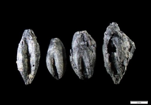
Carbonized germinated grains found at Uppåkra, Sweden.
Credit: Mikael Larsson[/caption] “We found carbonised malt in an area with low-temperature ovens located in a separate part of the settlement. The findings are from the 400-600s, making them one of the earliest evidence of beer brewing in Sweden,” says Mikael Larsson, a specialist in archaeobotany, the archaeology of human-plant interactions.

Beer: a hazy history

The brewing, consumption and distribution of beer was an important aspect of many ancient societies across the world. By way of example, beer was produced in Mesopotamia as far back as 4000 BCE. There have been suggestions that Mesopotamians could have been drinking beer in 10,000 BCE, but there is little evidence to back this up. We do know, though, that beer was drunk in Northern China 9,000 years ago. [caption id="attachment_8765" align="aligncenter" width="640"] Beer has played an important role in society for at least 10,000 years. Credit: Pixabay[/caption] But for the Nordic countries, evidence of early beer consumption is scarce, as there are no written sources from before the Middle Ages in this region. Knowledge of beer production has been, so far, dependent on botanical evidence. Existing findings are limited, though early traces of malt for beer brewing have been discovered in two other places in the Nordics. One is in Denmark from 100 CE and one is in Eketorp on Öland from around 500 CE. “We often find cereal grains on archaeological sites, but very rarely from contexts that testify as to how they were processed. These germinated grains found around a low-temperature oven indicate that they were used to become malt for brewing beer,” says Larsson.

A centre of political & religious power

Uppåkra, where the grains were discovered, is the largest known Iron Age settlement in southern Scandinavia. It served as a densely populated political and religious centre of power for more than 1000 years, from the 100s BCE to the 1 000s CE. Many imported and luxury items have been discovered at Uppåkra. Jewellery and glass bowls found on the sites indicate that the location was a rich, bustling trading centre – one that would likely play host to Scandinavia’s oldest brewery.

Scandinavia’s oldest brewery

Making beer is a two-stage process. Before the actual brewing, the malting process must be executed. Grains are soaked in water, which will allow the grain to germinate. While that’s happening, enzymatic activities convert both proteins and starches of the train into fermentable sugars. When enough sugar has been formed, the germinated grain is dried in an oven with hot air. It was this oven that was discovered and studied in Uppåkra, Sweden. Larsson explains: “Because the investigated oven and carbonised grain was situated in an area on the site with several similar ovens, but absent of remains to indicate a living quarter, it is likely that large-scale production of malt was allocated to a specific area on the settlement, intended for feasting and/or trading.”]]>

Categories
Breaking News

3,000 year old funeral rituals show earliest evidence of human hair dye

Early funeral rituals: mysteries revealed A collaborative excavation from the University of Granada in Spain, the University of Tübingen in Germany and the University of Cambridge in the United Kingdom has uncovered around one hundred bodies; many of which have been affected by hitherto undiscovered funeral rituals, including hair that has been dyed red. The bodies were uncovered in a Biniadris Cave, which would have been frequented by different societies over a period of between 3,300 and 2,600 years ago.   [caption id="attachment_8737" align="aligncenter" width="500"] View of the entrance to Biniadris Cave in Menorca. Credit: University of Granada[/caption]

Hair dye and its symbolic value

Two archaeological researchers from the University of Granada, Dr. Eva Alarcón García and Dr. Auxilio Moreno Onorato, have written: “Evidently, the red tufts of hair must have had symbolic value for these social groups. They were perfectly cut and deposited in containers of varying sizes that were made of different materials (metal, leather and even wood), which were then hidden in specific parts of the cave.” [caption id="attachment_8738" align="aligncenter" width="500"] Remains discovered in Biniadris Cave, Menorca. Credit: University of Granada[/caption]

A unique combination of funeral rituals

As well as colouring the deceased’s hair red, members of this society practiced a collection of funeral rituals that reflect their local religion and its symbolism. For example, the researchers found that the bodies were usually placed in the centre of the cave, where they were surrounded by ceramic fragments. Trepanation, a symbolic act in which a hole is drilled into the skull of the deceased, was also practiced on many of the bodies. Dr. Eva Alarcón García notes: “There are no precedents for these kinds of social practices in the Iberian Peninsula and they are unique to the Balearic Islands. The buried were placed in the middle of the cave and a variety of elements were used during the rituals, such as plant materials (branches and trunks), ceramic vessels that must have played an important role given the degree of fragmentation they exhibit, iron oxide ores (‘ochre’), etc.”  

Ritualistic attire for Menorca’s deceased

The team of archaeologists also found that many of the bodies were dressed up in ritualistic attire. Needles, fabric and ancient V-perforated buttons made from bones and wild boar tusks were discovered in the cave, close to the bodies. The remains of the hairs and fabric are currently being studied through carbon-14 dating at the University of Cambridge. “Undoubtedly, the findings at the Biniadris Cave will raise many questions and pave the way for new lines of research, not only from archaeological perspectives but also from anthropological ones. For now, the main objective of the research is to solve the enigmas presented by these mysterious funeral rituals performed long ago in the Biniadris Cave,” they conclude.]]>

Categories
Breaking News

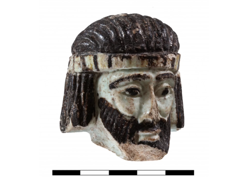
Could this 2,800 year old sculpture show us the face of a biblical king?

Credit: Gabi Laron[/caption]
A tiny representation of a momentous past

The glazed ceramic sculpture is of a man with long, black hair and a beard. He is wearing a yellow and black headband, which pulls the hair away from his dark, almond-shaped eyes. At only 5.1 cm x 5.6 cm, this tiny head is thought to have been part of a small statuette, according to archaeologists. At full size, the statuette would have been around 20 cm x 25 cm. Professor Robert Mullins from Azusa Pacific University’s Department of Biblical and Religious Studies is also co-director of excavations in the ancient city. He said: “Despite the head’s small and innocuous appearance, it provides us with a unique opportunity to gaze into the eyes of a famous person from the past — a past enshrined in the Book of Ages [the Hebrew Bible].”  

Whom does the sculpture depict?

Given that it was found inside what is thought to be an administrative building at the city’s peak, it is likely that the sculpture is of an elite person. The first assumptions have been that it was a biblical king; though Mullins and his team have yet to undertake the necessary research to prove or disprove this theory. So if it is indeed a king, whom would it have been? [caption id="attachment_8706" align="aligncenter" width="500"] Credit: Gabi Laron[/caption]  

Power struggles in Abel Beth Maacah

In the early stages of research, the team performed radiocarbon dating on the organic materials that were found in the same room as the sculpture. According to the findings, the object would have been constructed some time between 902 BC and 806 BC. The control of Abel Beth Maacah fluctuated greatly during this period. This is down to the fact that it sat at the border of 3 separate kingdoms: Israel, Tyre and Aram-Damascus. Borders were changing continually, leaving Abel Beth Maacah to be under the jurisdiction of different nations. Taking likelihood into account, Mullins thinks the sculpture could depict one of 3 possibilities: King Ahab of Israel, King Hazael of Aram-Damascus, and King Ethbaal of Tyre. However, there are many other candidates, he has said.  

Future research to confirm identity

The sculpture will be displayed at the Israel Museum in Jerusalem, while the scientists are publishing a paper on the discovery for the journal Near Eastern Archaeology. Excavations at Abel Beth Maacah are undertaken by Azusa Pacific University and the Hebrew University of Jerusalem. Joining Professor Mullins are Naama Yahalom-Mack and Nava Panitz-Cohen, both from the Hebrew University of Jerusalem. They will continue to arrange excavations of the large building into summer 2018. Archaeologists are hopeful that new information will arise to determine the identity of this miniature sculpture.]]>

Categories
Breaking News

Saladin Mystery Solved – The History News of the Week

Mystery of Saladin’s Death solved? The mystery surrounding Saladin’s death may have finally been solved. Famed for leading armies against the Crusaders, and being Sultan of an area that stretched from what is now Iraq to North Africa, Saladin died at the age of 56, some 800 years ago. There are few details about his death, other than that he became ill in 1193, and died two weeks later. Now, Stephen J. Gluckman, MD, professor of medicine at the University of Pennsylvania School of Medicine, has come up with a diagnosis. He theorises that Saladin succumbed to typhoid fever, a disease common in the region at the time. Easily cured with antibiotics nowadays, the disease would have been far more dangerous in the Middle Ages. Gluckman has based his diagnosis on what is known about Saladin’s medical history. “Practicing medicine over the centuries required a great deal of thought and imagination,” he says. “The question of what happened to Saladin is a fascinating puzzle.” Dr. Gluckman delivered his diagnosis at the 25th annual Historical Clinicopathological Conference, held May 4 at the University of Maryland School of Medicine. The conference is devoted to the diagnosis of disorders that afflicted historical figures. No Hidden Rooms in Tutankhamun’s Tomb Radar scans have provided conclusive evidence that there are no hidden rooms in Tutankhamun’s Tomb, according to Egypt’s Ministry of Antiquities. It has long been speculated that the young Pharaoh’s spectacular tomb may contain hidden chambers yet to be seen by archaeologists. However, Mostafa Waziri, Secretary General of the Supreme Council of Antiquities, announced that an Italian team has conducted extensive studies with ground-penetrating radar, showing the tomb did not contain any hidden, man-made blocking walls. The findings have been presented to an international conference in Cairo. “Our work shows in a conclusive manner that there are no hidden chambers, no corridors adjacent to Tutankhamun’s tomb,” Dr. Porcelli said, according to news.com.au. According to the ministry, the findings should bring to a close speculation over hidden rooms in the famous tomb. “…the hypothesis concerning the existence of hidden chambers or corridors adjacent to Tutankhamun’s tomb is not supported by the GPR data,” the ministry said in a statement. New Evidence for the Kingdom of David and Solomon? [caption id="attachment_8602" align="alignnone" width="400"]This is a composite aerial photograph of the four-room residency. Image credit:
Sky View and Griffin Aerial Imaging, edited by Yair Sapir[/caption] Archaeologists in Israel claim to have discovered new evidence proving the existence of the Kingdom of David and Solomon. Significantly, the new findings also give an idea of the scope of the kingdom, suggesting it extended beyond the vicinity of Jerusalem. The existence of the biblical kingdom has long been a matter of contention. Until now, little evidence of royal construction has been found in the area where the kingdom supposedly was. The Kingdom of David and Solomon supposedly reigned in the 10th century BCE. Professor Avi Faust and Dr. Yair Sapir from Bar-Ilan University have excavated a large, four room residence which was destroyed in the 8th century BCE. The large building had at least two stories, with its ground floor extending over 225 square metres. “Surprisingly, radiocarbon dates from within the floor make-up and from within a foundation deposit that was placed below the floor indicate that the building had already been erected in the 10th century BCE, between the late 11th century and the third quarter of the 10th century BCE,” said Professor Faust in a Bar-Ilan University press release. “This date is in line with other finds related to the construction, like the foundation deposit itself.” The residence is located at Tel ‘Eton in the Shephelah (20 km. southeast of the city of Qiryat Gat). According to Faust and Sapir, the building would have been constructed in a style similar to other Israelite sites, and points to a rising ‘Israelite polity’ in the region. Their excavations reveal that the site around the building would have been expanding in the 10th century. Faust and Sapir note in their research, published in the journal Radiocarbon, that any association with King David would be based on ‘circumstantial grounds’. Nevertheless, both the timing and location of the site would sync up with when David and Solomon supposedly lived. They write in their study: “…if someone thinks that there was no king by the name of David, we should find another name to call the highland king in whose time the region was incorporated into the highland kingdom”. Featured image: Saladin à Jérusalem, courtesy of Moreau.henri, via Wikimedia Commons ]]>

Categories
Breaking News

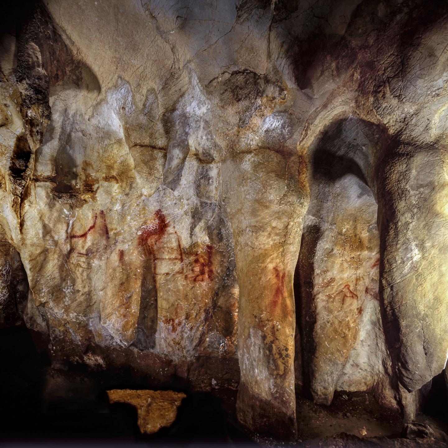
Neanderthals Made Cave Paintings – The History News of the Week

Neanderthals Created 64,000 Year-Old Cave Paintings Neanderthals, and not humans, created the world’s oldest cave paintings, new research claims. The findings add to growing evidence that our closest extinct evolutionary cousins were far from their barbaric, unsophisticated representation in popular culture. Scientists from the Max Planck Institute for Evolutionary Anthropology and University of Southampton show that paintings in three Spanish caves are over 64,000 years old. That’s 20,000 years before the first humans arrived in Europe. The research has been published in the journal Science. It suggests that Neanderthals thought symbolically, an attribute usually only attributed to modern humans. “Artefacts whose functional value lies not so much in their practical but rather in their symbolic use are proxies for fundamental aspects of human cognition as we know it,” said Dirk Hoffmann, from the Max Planck Institute, in a press release. Cave painting has, until now, been entirely attributed to modern humans, largely due to difficulties in dating it precisely. The international team behind the new study used the uranium-thorium method to date tiny carbonate deposits that have built up on top of the cave paintings. Traces of uranium and thorium indicate when the deposits formed. This allows a minimum age for the paintings underneath to be determined. Joint lead author Dr Chris Standish, an archaeologist at the University of Southampton, said: “This is an incredibly exciting discovery which suggests Neanderthals were much more sophisticated than is popularly believed. “Our results show that the paintings we dated are, by far, the oldest known cave art in the world, and were created at least 20,000 years before modern humans arrived in Europe from Africa – therefore they must have been painted by Neanderthals.” Infant Cranial Modification Linked to Identity in Ancient Andes A new study claims that the binding and reshaping of infants’ skulls in the Andes between 1100 and 1450 was linked to identity and inequality. Prior to the expansion of the Inca Empire into the region that is now Peru, cranial modification of infants was hugely popular. Assistant professor of anthropology at Cornell University Matthew Velasco argues that these head-shaping practices were connected to political solidarity and social inequality. The anthropologist analysed hundreds of skeletal remains from multiple tombs in the Colca Valley of highland Peru. One key finding was that modification grew in popularity over the period of investigation. Prior to 1300, cranial modification was rare, while by the end of the period it had risen to 73.7% of the population. “The increased homogeny of head shapes suggests that modification practices contributed to the creation of a new collective identity and may have exacerbated emerging social differences,” Velasco said. “Head shape would be an obvious signifier of affiliation and could have encouraged unity among elites and increased cooperation in politics.” Velasco found that women with modified heads had better access to varied food options and were less likely to encounter violence in their lives. This, he suggests, points to a connection between cranial modification and inequality. A sixteenth century Spanish colonial document Velasco examined described groups moulding skulls into the shapes of volcanoes from their origin myth. “If this is true, then cranial modification reflects a deeply religious worldview and was fundamental to a person’s being and existence, and not simply a fashion statement,” Velasco said. Velasco’s findings have been published in the journal Current Anthropology. Ninth Century Rock Art Destroyed Unique paintings on a ninth century temple in Hyderabad have been whitewashed by villagers, according to the Times of India . The cave temples, located on a hillock, are one of the oldest structures in the region. However, their artworks were not on any protected lists for archaeological sites. “They were initially Jain caves that were later converted into a Lord Shiva temple after installation of shivalingam. During the recent Shivaratri celebrations, the villagers whitewashed the paintings on the pillars and cave walls,” Aravind Arya Pakide, an archaeology expert, told the Times of India. “It is complicated to restore these paintings. In the name of beautification, they are using acrylic paints and damaging the archaeologically-significant structures.” Ceiling paintings on an ornate gateway have been particularly badly affected, with only traces of the figures depicted remaining, the Times of India article reports. Featured image: La Pasiega, Section C, Cave Wall With Paintings. The ladder shape composed of red horizontal and vertical lines (centre left) dates to older than 64,000 years and was made by Neanderthals. Image credit: © P. Saura ]]>

Categories
Breaking News

An Iron Throne in the Great Pyramid? – The History News of the Week

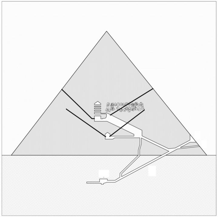
Cheops Pyramid Void an Iron Throne Room? An Italian archaeologist has come up with a theory for the huge void recently discovered in the Cheops (Khufu) Pyramid. In November 2017, the results of the Scan Pyramids project were published in the journal Nature. They revealed a huge void measuring at least thirty metres long within the Pyramid of Cheops. The project used a non-invasive technique based on the measurement of muons: elementary particles that are generated in cosmic rays and absorbed differently depending on the materials they go through. Giulio Magli, Director of the Department of Mathematics and Professor of Archaeoastronomy at the Politecnico di Milano, has now come up with a possible explanation for the mysterious void, suggesting it could be a Pharaoh’s “iron throne”. “Cheops Pyramid, built around 2550 BC, is one of the largest and most complex monuments in the history of architecture. Its internal rooms are accessible through narrow tunnels, one of which, before arriving at the funerary chamber, widens and rises suddenly forming the so-called Great Gallery,” Magli explained in a press release. “The newly discovered room is over this gallery, but does not have a practical function of “relieving weight ” from it, because the roof of the gallery itself was already built with a corbelled technique for this very reason.” Magli continued: “There is a possible interpretation, which is in good agreement with what we know about the Egyptian funerary religion as witnessed in the Pyramids Texts. In these texts it is said that the pharaoh, before reaching the stars of the north, will have to pass the “gates of the sky” and sit on his “throne of iron”. It would be possible to check Magli’s hypothesis by exploring the north shaft of the Cheops Pyramid. At present, it’s not known for sure that the north shaft leads into the mysterious void, as the available images are only approximations of the pyramid’s layout. Dual Migration Routes to Scandinavia Suggested by new Genomic Data The first human settlers to Scandinavia arrived by two distinct migration routes, new research suggests. The new study, which has been published in the journal PLOS Biology, also suggests that the resulting mixed population genetically adapted to the extreme environmental conditions. Although there is consistent evidence of a human presence in the Scandinavian peninsula from around 11,700 years ago, the migration routes and genetic makeup of the first Scandinavians have until now remained elusive. Researchers from Uppsala University sequenced the genomes of seven hunter-gatherers excavated from across Scandinavia and dated to be between 9,500 to 6,000 years old. They determined from their findings that migrations into Scandinavia likely followed two routes, one from central Europe and one from the Northeast along the Norwegian Atlantic Coast. The two groups met and mixed in Scandinavia, creating a genetically diverse population with variants that haven’t been passed along to modern Europeans. Several genetic variants in the hunter-gatherers were found to be linked to a gene associated with physical performance. The study authors hypothesise that this could be part of the physical adaption to cold weather. In addition, the hunter-gatherers had a high-frequency of genetic variants linked to reduced skin pigmentation, a known adaptation to environments with low UV radiation, such as those at high latitude. “We used cutting-edge genomic approaches to investigate hypotheses about the early colonization of northern Europe after the ice-sheet of the last glaciation retracted. It is really great to see how evidence from different disciplines can be combined to understand these complex past demographic processes,” said population geneticist Torsten Günther, one of the lead authors, in a press release. Council Accused of Covering Up Major Archaeological Find North Somerset Council in the UK has been accused of trying to keep a major archaeological find quiet, according to the BBC. The pre-Christian cemetery, containing over 300 graves, was discovered in the village of Yatton in 2017, during works to develop the land for housing. Some have claimed that the local council attempted to keep the find “hush-hush”, although the council told the BBC that publicising cemetery excavations was not common practice. “I’m amazed there hasn’t been more public communication between the archaeologists, the developer and the local community – it’s almost scandalous,” Mark Horton, professor of archaeology at the University of Bristol, told the BBC. “It’s normal procedure – even if the public aren’t allowed inside – to put information on the outside about what’s been found and it does seem to be really bad practice that there’s such secrecy about this project.” The remarkable site is close to both an Iron Age fort and a Roman hill fort. An archaeologist for the council claimed that the fact human remains were found at the site meant that information about it was not made widely available to the public. “It seems like we’ve been covering it up, but it’s common practice not to publicise the excavation of cemeteries like this to avoid risking the integrity of the site,” said Cat Lodge, archaeologist for the council. Boor Homes, the company developing the site, said in a statement to the BBC that “no identified grave goods” or “datable artefacts” had been unearthed, while the skeletons “are in varying states of survival”. Featured image: North-south section of the Great Pyramid showing (dust-filled area) the hypothetical project of the chamber, in connection with the lower southern shaft. The upper southern shaft does not intersects the chamber (as instead suggested by the section) because, when viewed in plan, it is displaced to the west with respect to the Great Gallery. Courtesy of Giulio Magli]]>

Categories
Breaking News

Caesar's Landing in Britain – The History News of the Week

Site of Julius Caesar’s Invasion of Britain Discovered Archaeologists have discovery the first evidence of Julius Caesar’s invasion of England. Based on their findings, the archaeologists from the University of Leicester suggest the first landing of Caesar’s fleet in Britain took place in 54BCE at Pegwell Bay on the Isle of Thanet, at the north-east point of the county of Kent. Significantly, the topography of Pegwell Bay, with its visibility from the sea, large open bay and nearby higher ground, is consistent with Caesar’s account of the first landing. The project came about following the discovery of a large defensive ditch in archaeological investigations prior to the building of a new road close to a hamlet in Thanet. This ditch, in Ebbsfleet, is similar to Roman defences at Alésia in France where the decisive battle in the Gallic War took place in 52 BCE. 4-5 metres wide and 2 metres deep, the ditch has been dated by pottery found on site and radio carbon dating to the first century BCE. The archaeological team believe the site covers up to 20 hectares, and the fort was constructed to protect the ships of Caesar’s fleet that had been drawn up on a nearby beach. Dr Andrew Fitzpatrick, research associate from the University of Leicester’s School of Archaeology and Ancient History, said: “The site at Ebbsfleet lies on a peninsular that projects from the south-eastern tip of the Isle of Thanet. Thanet has never been considered as a possible landing site before because it was separated from the mainland until the Middle Ages. “However, it is not known how big the Channel that separated it from the mainland (the Wantsum Channel) was. The Wantsum Channel was clearly not a significant barrier to people of Thanet during the Iron Age and it certainly would not have been a major challenge to the engineering capabilities of the Roman army.” Fitzpatrick detailed the similarities between Caesar’s account and the Thanet site. “Sailing from somewhere between Boulogne and Calais, Caesar says that at sunrise they saw Britain far away on the left-hand side. As they set sail opposite the cliffs of Dover, Caesar can only be describing the white chalk cliffs around Ramsgate which were being illuminated by the rising sun,” he explained in a press release. “Caesar describes how the ships were left at anchor at an even and open shore and how they were damaged by a great storm. This description is consistent with Pegwell Bay, which today is the largest bay on the east Kent coast and is open and flat. The bay is big enough for the whole Roman army to have landed in the single day that Caesar describes. The 800 ships, even if they landed in waves, would still have needed a landing front 1-2 km wide. “Caesar also describes how the Britons had assembled to oppose the landing but, taken aback by the size of the fleet, they concealed themselves on the higher ground. This is consistent with the higher ground of the Isle of Thanet around Ramsgate. “These three clues about the topography of the landing site; the presence of cliffs, the existence of a large open bay, and the presence of higher ground nearby, are consistent with the 54 BCE landing having been in Pegwell Bay.” Sea Level Rises Threatening 13,000 US Archaeological Sites Rising sea levels could impact thousands of archaeological sites on the southeastern US Gulf and Atlantic coasts, new researched published in the journal PLOS ONE claims. David Anderson from the University of Tennessee, Knoxville, USA, and colleagues predict that if projected trends in sea level rises continue, up to 13,000 recorded archaeological sites will be submerged by a 1 metre rise in sea level by the end of the century. This figure does not take into account sites that have not yet been unearthed, suggesting the damage could be even greater. To estimate the impact of sea-level rises, Anderson and his team studied data from the Digital Index of North American Archaeology (DINAA). DINAA aggregates archaeological and historical data sets from the past century from numerous sources, providing a comprehensive insight into the history of human settlement. According to a University of Tennessee statement, large linked data sets like DINAA are vital for showing what is at threat from sea level rises, and can help in planning a response, whether it be mitigation, or taking samples from sites that are at risk. “Sea-level rise in the coming years will destroy vast numbers of archaeological sites, buildings, cemeteries, and cultural landscapes. Developing informatics capabilities at regional and continental scales like DINAA (Digital Index of North American Archaeology) is essential if we are to effectively plan for, and help mitigate, this loss of human history,” Anderson noted. Secrets of 1-900-Year-Old Mummy Revealed With X-Rays Scientists are using pioneering techniques to unravel the mysteries of a young girl mummified in Egypt 1,900 years ago. The mummy was subjected to an all-day X-ray scattering experiment at the Argonne National Laboratory by scientists and students from Northwestern University. It was the first time the technique had been applied to study a human mummy. “This is a unique experiment, a 3-D puzzle,” said Stuart R. Stock, research professor of cell and molecular biology at Northwestern University Feinberg School of Medicine, who led the synchrotron experiment. “We have some preliminary findings about the various materials, but it will take days before we tighten down the precise answers to our questions. We have confirmed that the shards in the brain cavity are likely solidified pitch, not a crystalline material.” The Roman-Egyptian mummy is one of only approximately 100 portrait mummies in the world. Portrait mummies have a lifelike painting of the deceased individual on the mummy wrappings, directly over the deceased’s face. These ‘2D portraits’ were introduced to Egyptian culture by the Romans. Previously, idealised 3D images had been used, such as the iconic burial mask of Tutankhamun. Measuring just 3 feet in length, the girl’s body is swaddled in linen. The outer wrappings have been arranged into an ornate geometric pattern. The image of the face is painted with beeswax and pigment. It gazes outward with a serene look, the body dressed in a crimson tunic and gold jewellery. The students from Northwestern University found that the mummy of the girl, which is stored at Garrett-Evangelical Theological Seminary on Northwestern’s Evanston campus, had notable differences to portrait mummies at Phoebe A. Hearst Museum of Anthropology at the University of California, Berkeley. This suggests it came from a different workshop despite being discovered at the site of Hawara, close to Tebtunis, where the Hearst Museum’s mummy portraits are originally from. “Intact portrait mummies are exceedingly rare, and to have one here on campus was revelatory for the class and exhibition,” said Marc Walton, a research professor of materials science and engineering at Northwestern’s McCormick School of Engineering. As well as providing insights into Egyptian-Roman mummification techniques, the ground-breaking studies being carried out by Northwestern University will help guide preservation of the mummy. The research will culminate in an exhibition at Block Museum titled: “Paint the Eyes Softer: Mummy Portraits from Roman Egypt.” Featured image: The Ebbsfleet Excavation with Pegwell Bay and Ramsgate. Image courtesy of University of Leicester. ]]>

Categories
Breaking News

Inequality’s Deep Roots – The History News of the Week

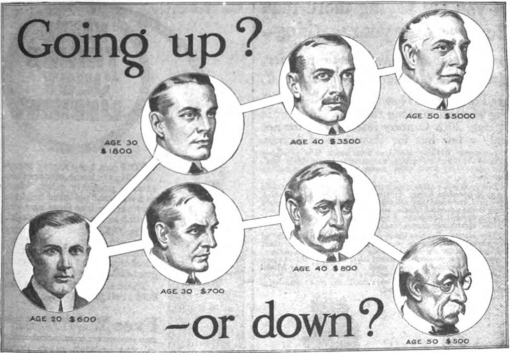
Inequality Started with the Rise of Agriculture New research claims that the rise of economic inequality in human societies can be traced all the way back to the dawn of agriculture. Published in the journal Nature, the research involved academics from fourteen different institutions, and was led by Tim Kohler from Washington State University (WSU). The findings have profound implications for modern societies, the authors believe. “Inequality has a lot of subtle and potentially pernicious effects on societies,” Kohler explained. The researchers based their findings on the Gini coefficient, a commonly used measure of inequality developed over a century ago by Italian statistician and sociologist Corrado Gini. On this system, a country with total wealth equality would have a Gini coefficient of zero, while a country with all the wealth concentrated in one household would have a Gini Coefficient of one. House sizes were compared at 63 different archaeological sites, and the researchers used this data to assign Gini coefficients. It was found that hunter-gatherer societies typically had lower wealth disparities, with a median Gini of .17. This is likely because their nomadic lifestyles would have made wealth accumulation difficult, and passing it on to future generations even more so. Small-scale, low intensity farmers (horticulturalists) had a median Gini of .27, while large scale agricultural societies had a median Gini of .35. One remarkable observation by Kohler’s team is that inequality continued to rise in the Old World, but plateaued in the New World. According to Kohler, this is down to the ability of Old World societies “to literally harness big domesticated mammals like cattle and eventually horse and water buffalo.” Draft animals, which were not available in the New World, let rich farmers till more land and expand into new areas. This increased their wealth while ultimately creating a class of landless peasants. “These processes increased inequality by operating on both ends of the wealth distribution, increasing the holdings of the rich while decreasing the holdings of the poor,” the researchers write in their study. Bronze metallurgy and a mounted warrior elite further increased the Gini coefficient in the Old World, allowing some individuals to live in massive houses and make territorial conquests, the benefits of which were inherited by their descendants. The researchers’ models put the highest Gini numbers in the ancient Old World at .59, close to that of contemporary Greece’s .56 and Spain’s .58. It is well short of China’s .73 and the United States .80, a 2000 figure cited in the Nature paper. The 2016 Allianz Global Wealth Report puts the U.S. Gini at .81 and Kohler said in a WSU press release he has seen the U.S. Gini reported as high as .85, “which is probably the highest wealth inequality for any developed country right now.” For Kohler, the current high Gini number in the US should be a cause for concern. “People need to be aware that inequality can have deleterious effects on health outcomes, on mobility, on degree of trust, on social solidarity–all these things,” he said in a WSU statement. “We’re not helping ourselves by being so unequal.” Kohler has documented four periods of growing inequality among the ancient Pueblo people of the American Southwest, all of which ended in violence and greater equality. The last of these was particularly dramatic – coinciding with the complete depopulating of the Mesa Verde area. “In each case, you see not just this decline in Gini scores, but we also see an increase in violence that accompanies that decline,” Kohler said. “We could be concerned in the United States, that if Ginis get too high, we could be inviting revolution, or we could be inviting state collapse. There’s only a few things that are going to decrease our Ginis dramatically.” 14 Million Years Ago, Madrid Was a Desert A new study claims that the central Iberian Peninsula, an area that covered what is now Madrid, was an arid savanna during the middle Miocene period. The research, led by the Complutense University of Madrid and published in the journal PLOS ONE, compared mammal assemblages from different localities in Africa and South Asia with those that inhabited the Iberian central area 14 million years ago. Through paleontological studies of the fossil vertebrate remains found at the Somosaguas site in Madrid, the researchers have been able to infer the environment that existed there. The central premise behind the research is that the body size of every species is largely influenced by the environmental conditions of their habitat. Elephants in humid places such as Asian jungles, for instance, are smaller than those living in dry places like African savannas. “Based on this premise, the distribution of sizes within a mammal community can offer us valuable information about its climatic context”, explains Iris Menéndez, a researcher at the Department of Paleontology of the UCM and the Institute of Geosciences (UCM and CSIC). From their analysis, the palaeontologists have inferred that the centre of the Iberian Peninsula witnessed ‘a very arid tropical climate with a high precipitation seasonality’. After a brief wet period, the annual dry season could last up to ten months. “These results confirm the previous inferences on the savanna environment of Somosaguas in the Miocene, but placing this habitat at their driest estimated, within the limits between the savanna and the desert”, says Menéndez. Climatic parameters from more than 60 modern day Asian and African sites were compiled as a point of comparison for the study. “For this purpose, we made a compilation of information on mammalian fauna lists, their body sizes, and climatic parameters for these localities, such as temperatures and precipitation. Based on this data, we developed statistical models suitable for the inference of different climatic parameters in the past”, explained the UCM researcher. “We included the information on the 26 mammal species found in the Somosaguas site, which allowed us to infer the environment by comparison with the extant assemblages”. Neanderthals Lived in Spain for 3,000 Years Longer Than Thought Neanderthals survived in Spain long after they had died out every else, new research claims, suggesting our extinct cousins lived in Spain 3,000 years longer than is traditionally believed. According to the international team of researchers who carried out the study, the findings suggest that the process of modern human populations absorbing Neanderthal populations through interbreeding was not a regular, gradual wave of advance but a “stop-and-go, punctuated, geographically uneven history.” Over a period of ten years the researchers excavated three new sites in southern Spain, where they unearthed evidence of Neanderthal materials from as recently as 37,000 years ago. “Technology from the Middle Paleolithic in Europe is exclusively associated with the Neanderthals,” said Dr. João Zilhão, from the University of Barcelona and lead author of the study. “In three new excavation sites, we found Neanderthal artefacts dated to thousands of years later than anywhere else in Western Europe. Even in the adjacent regions of northern Spain and southern France the latest Neanderthal sites are all significantly older.” The Middle Paleolithic spanned from 300,000 to 30,000 years ago. It is widely acknowledged that during this time, anatomically modern humans started to move out of Africa and assimilate coeval Eurasian populations, including Neanderthals, through interbreeding. “We believe that the stop-and-go, punctuated, uneven mechanism we propose must have been the rule in human evolution, which helps explaining why Paleolithic material culture tends to form patterns of geographically extensive similarity while Paleolithic genomes tend to show complex ancestry patchworks,” Dr. Zilhão said. Dr. Zilhão believes that discovering and analysing new Neanderthal sites is the key to understanding the pattern of human evolution, and the true fate of the Neanderthals. “There is still a lot we do not know about human evolution and, especially, about the Neanderthals,” said Dr. Zilhão. “Our textbook ideas about Neanderthals and modern humans have been mostly derived from finds in France, Germany and Central Europe, but during the Ice Ages these were peripheral areas: probably as much as half of the Paleolithic people who ever lived in Europe were Iberians. Ongoing research has begun to bear fruit, and I have no doubt that there is more to come.” The study has been published in the journal Heliyon. Featured Image: Illustration from a 1916 advertisement for International Correspondence Schools, Scranton, Pennsylvania, a vocational school, in the back of a US popular science magazine. During the Industrial Revolution, income inequality in the US was very great, and education was seen as a route to social mobility. This advertisement uses the threat of poverty to recruit students. Part of advertising copy that appeared below the picture: “Here is your future charted for you, based on the actual average earnings of trained and untrained men. Which way will you go? You’ll either go up, through training, to a position that means good money and more comforts as the years go by, or you’ll go down, through lack of training, into the ranks of the poorly paid.” ]]>